By Johna Till Johnson
Photos by Vladimir Brezina
 Sunken Meadow State Park to Pier 40, Manhattan
44 nautical miles (51 land miles)
.
(click on photos to expand them—they look a lot better when they’re BIGGER!)


Our campsite at High Water Beach…
I slept wonderfully that night on High Water Beach, despite the risk of being flooded out in the middle of the night by the high tide. Knowing the boats were secured, and that Vlad was checking on them, made it easy for me to sleep.
Vlad wasn’t so lucky—between general restlessness and checking on the boats, he got only a couple hours of sleep.
In the morning, all the signs were that the water had indeed come very close to us. But we were still dry.

… is lit up by the rising sun

Still dry!

Even the laundry has dried a bit overnight…
As we packed up, we discussed where to camp that night. If we made it as far as we hoped, we could spend the night on one of the little islands that dot the western end of Long Island Sound. We had a particular island in mind, in fact. Then we would have just a short paddle home tomorrow.
The drawback of that plan, as Vlad pointed out, was that tomorrow there would be no point in arriving at Throgs Neck, at the entrance to the East River, before about 1 PM—before that we would be fighting, rather than riding home, the strong East River current. But the islands were only about an hour or two from Throgs Neck. So we’d be, in essence, spending a full extra day, and camping an extra night, just to paddle a few hours.
So if we made it to the islands by this evening, why not just keep going for those few hours? That meant being at Throgs Neck at 1 AM rather than 1 PM—and paddling all night. But we’d done that before. It’s actually incredibly peaceful to paddle at night—there’s almost no traffic. And it was likely to be a beautiful night: The moon was waning gibbous (nearly full) and today and tomorrow were predicted to be perfectly clear.
We finally decided to play it by ear. We’d see how far we got, and make our decision at sundown.

We say goodbye to High Water Beach
And so we set off, on what we suddenly realized might be the final leg of our journey.
We said goodbye to High Water Beach, and the fishermen who had spent the night on it next to us, and paddled off down the Sound.

Cormorant rock

Yesterday’s smokestacks, now close at hand

Mirror-smooth water

We approach Eatons Neck
We had some current with us at first, and the wind against us was light. For the first few hours, that was delightful. But then the sun rose higher, and it got hotter.
And hotter.
We began to pray for wind—even against us.

But there is not even a hint of a breeze…
Vlad was yawning, both from lack of sleep and from the heat. (Heat is about the only thing that bothers him.) I wasn’t doing too badly, but we both had to keep splashing ourselves. Normally, I’d do a bow dip—or even better, a roll—but I had a bag of garbage lashed to my deck, and I really didn’t want to flood it with water. So we had to be content with splashing ourselves (and occasionally, each other).
Without even discussing it, we didn’t land for lunch. Instead, we rafted up and shared some sausages and cheese that I’d stowed in my day hatch. We didn’t want to do anything that might interfere with the possibility of making it home without having to camp another night…

We raft up for lunch, feeling the heat
As we paddled, the land around grew ever more familiar:

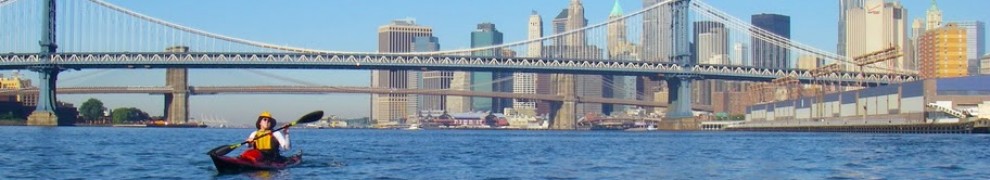
Our first glimpse of New York City, still forty miles away, on the horizon
There was the beach we’d camped on one time, more than a year ago. Oh look! There went a barge—the first one we’d seen since leaving New York Harbor. And what were those distant towers low on the horizon—could that be the city?
.
Up ahead was a beach we’d dubbed The Beach of Squirting Clams, because, when we’d picnicked there one day, we’d been surprised to see jets of water shooting up from the sand. We later figured it out it was the clams, buried under the sand, ejecting waste water. (Um, yeah, that would be “peeing”.)
We kept paddling. And it got hotter. And hotter. We amused ourselves by tracking the buoys—locating them on the chart, then paddling up to them to make sure they were what they were supposed to be. (Actually, this was a training exercise for me, as part of my preparation for the 3* exam in the fall.) Anything to keep awake!
By about 3 PM Vlad looked so downcast from the heat that I worried about heatstroke. We kept splashing ourselves with water, but it wasn’t enough.
“I know,” I said. “Let’s get to the Beach of Squirting Clams, and go for a dip in the water there.”
So that’s what we did. When we arrived, at 5 PM, a light wind had come up and it had started to cool down.
Nonetheless, I floated around in the water wearing my PFD. The water was cold, and amazingly refreshing. When I got back into the boat I felt ready for another day’s worth of paddling—which was a good thing, since that might just be in the cards.
It was time for us to decide. Were we going to go for it, or camp one more night?
We decided to go for it. But now we had the opposite problem. It wouldn’t do us any good to arrive at Throgs Neck much before midnight—the East River current would be against us until then. We were maybe only a couple of hours away. What to do with the remaining time?
“Why not stop and have dinner at City Island?” I suggested. City Island is the westernmost island in Long Island Sound, already within the boundaries of New York City. It’s a little maritime community, featuring (among other things) a couple of “dock and dine” restaurants. There we would be able to fortify ourselves with a warm meal (and a few cups of coffee) while waiting out the time before the East River current changed.
So we agreed: Dinner at City Island, then a midnight paddle home.

New York City grows larger…

Vast schools of fish, their fins sticking out, agitate the water
The tide was very low as we paddled across the shipping channel just west of Execution Rocks Light. We passed through fields of rocks that we had never seen so exposed before. And in patches all around, the water boiled with vast schools of fish, darting just under the surface, oblivious to our presence.

We paddle through the rocks off Pea Island, in the background—the island that we originally planned to camp on
Yet again, we arrived at our destination just as the sun was setting. There are two “dock and dine” restaurants at the northern tip of City Island, and we hesitated for a while, trying to decide which one to make for. Finally we went for JoJo’s City Island Lobster House. We’d already been to the other place, and JoJo’s seemed more lively.

Our little kayaks docked at JoJo’s at sunset
We tied the kayaks up to the dock bow and stern, using dock lines I’d bought on impulse from Amazon before the trip (see Long Island Kayak Circumnavigation: Postscript—Lessons Learned, forthcoming). We were a bit concerned about leaving the boats in the water, bouncing in each passing wake—but they were far too heavy to lift onto the dock.

Our last dinner of the trip at JoJo’s
We didn’t get a seat by the water, but that was okay—we’d had plenty of waterfront views. The hardworking staff brought us a lobster apiece, plus appetizers and salads. And then coffee: Two double espressos each! We would be sure to be awake for the last leg of the trip.
.
.
We left the restaurant around 10 PM. The boats were fine. We launched—for the last time!—by 10:30 PM.
The moon was struggling to break free from the clouds, but above there were stars. We made it to the Throgs Neck Bridge by 11:30 PM. We’d timed things perfectly: The current was just slack.
We turned and began to paddle down the East River.
The rest of that night swirls around my memory in a series of dreamy kaleidoscopic flashes. The moon came out, painting the black water with silver. We approached the familiar landmarks one by one: The Bronx-Whitestone Bridge. LaGuardia Airport. The decaying garbage transfer station. Rikers Island.
At North Brother Island, Vlad caught sight of a barge. My radio was on (the battery remarkably having stayed charged throughout the preceding nine days), and I heard the captain announce that he was planning to “round the brothers and head out”. So we knew which way the barge was headed, and were able to stay out of its way.
Then we were approaching Hell Gate Bridge—my favorite New York bridge. The current had been growing as we paddled, and we were making our way down the river at maybe six or seven knots. (At full speed, you can get up to eight or nine knots in Hell Gate). As always, the water was boiling with whirlpools and eddies, and our boats were tossed this way and that.
But we made it through without incident. Then out to Mill Rock, and a hard left to head down the river between Roosevelt Island and Manhattan.
We drifted down the East River, mostly just carried by the current, now and again spun around by an unseen eddy in the black water, looking at the lighted silhouettes of buildings in the city.
At the tip of Roosevelt Island is a tiny rock named U Thant Island (after the second Secretary-General of the UN). Cormorants roost there, and earlier in the season we’d seen the baby birds in nests.
As we drifted close to the island, we were treated to an incredible sight: In the soft glow of the moonlight and the city lights, there were dozens and dozens of the birds, both in their nests and standing on the ground—motionless. Completely asleep.
“Look at that!” we whispered to each other. “Do you see?” We paddled stealthily closer to the island, not wanting to wake the birds, before drifting past.

The East River bridges in sight
Then it was on to the three Lower East River bridges: Williamsburg, Manhattan, Brooklyn (my mnemonic for remembering them is BMW, south to north).
.
.
.

Except for the rushing current in the dark water, all is still at 3 AM as we pass under the Manhattan and Brooklyn Bridges
And suddenly we were at the Battery.
The big challenge now was, to paddle the last mile or so up the Hudson to Pier 40 against the current. The same strong current that had been propelling us would now be against us. Could we make it?
It was slow going, but by keeping close to the seawall, we were able to make reasonable headway—a knot or two. At the ferry terminal above North Cove we took the calculated risk of squeezing through the gap between the floating terminal and the seawall—something you’re not supposed to do. But the water was low, and we could see the metal spikes and hanging cables that threaten the unwary there pretty clearly.
And at long last, we were in sight of the Holland Tunnel ventilation shaft that marks Pier 40.
It was 4:30 AM. The air was just beginning to lighten, and the birds to awaken.
And we paddled into Pier 40 nine days and 22 hours after we had left.
Back at Pier 40!
We did it!

The first rosy light of dawn lights up the towers of the new World Trade Center complex as we unload the boats


Pingback: Long Island Kayak Circumnavigation: Day 9—High Water Beach | Wind Against Current
Amazing journey.
LikeLike
Thanks!
LikeLike
Reblogged this on " Una Voz en el Silencio ".
LikeLike
Thanks for reblogging!
LikeLike
everything is beautiful, thanks you ! :)
LikeLike
Awesome trip and an equally awesome job documenting it. Thanks again for posting–I’ve really enjoyed the read!
LikeLike
Just an incredible journey!! Have you ever considered doing tours like these? I really want to thank you so very much on your postings. Both my husband and I have truely enjoyed them. Our adventures are nothing in comparison to yours but your love of the Sound and the Rivers that surround Manhattan leave all of us counting the seconds to get back in the “yaks
LikeLike
We are happy you enjoyed our posts, Vicki! I see your own kayak posts on Facebook, so I know we are in the same boat, so to speak :-)
Tours? Sounds like real work…
LikeLike
Hi John–thanks for reading!
LikeLike
Paddling through the heat, through the night… Amazing!! Is it safe to paddle at night, could you see where you were going…?
LikeLike
Well, “safe” is all a matter of degree :-) but yes, paddling at night is pretty safe, if you plan well and know the area.
For one thing, we had a full moon (one of the few things we planned ahead on) and clear weather.
The NYC skyline is also usually well-lit—I’m not sure about night paddling in, say, Maine, where I hear there are rocks and things and it can be pitch-dark.
Finally, as mentioned, we did carry radios. That helps a LOT (and is recommended BCU procedure). You can hear the commercial vessels broadcasting their maneuvers, like the captain who let us know he was “rounding the brothers”–and that gives you enough guidance to stay out of the way.
LikeLike
Great writeup!
LikeLike
Thanks, John! If I were a puppy I’d be wriggling and wagging my tail…..
LikeLike
That was just wonderful, Johna, Vlad. I’ve been inthralled the whole way around – it’s such an achievement – the circumnavigation, and the postings. Congratulations to two modern day explorers :)
LikeLike
Thanks! It really was a turning point, in so many ways. Thanks for reading (and viewing).
LikeLike
I still haven’t caught up to the rest of your trip, but what a great kayaking voyage! The distances you two travel in a day are just staggering. I admire your fortitude.
LikeLike
Thanks! That’s actually one of the things we have in common–a shared love of paddling stupidly-long distances. It turns out that we’re both insatiably curious to know what’s around the next bend…..
LikeLike
I like the Foto from the New World Trade Center. I was only three times in N.Y., the first it was 1991 only for 1 day passing throug to the West Coast. I like it so much, that I spent 1992 one week there. I saw the old WTC and went to the terrace. The next time I was there in 2006 and I saw Ground Zero and a changed N.Y.
When I saw our photos I know it is time to see N.Y. again.
I liked certainly the other photos – it is great.
LikeLike
Susanne, it is DEFINITELY time to come back and see it again! Hope you do.
LikeLike
I’m just speachless….. THANKS for sharing this, absolutely amazing!
LikeLike
Wow, speechless?? Really? Thanks for the HUGE compliment! We appreciate your reading (and posting)!
LikeLike
What a great adventure you both shared. The photos are really amazing. I can just imagine the peace and calm of paddling through the night, although how you both stayed awake, is beyond me. What a great idea are those “dock and dine” restaurants. A real life-saver, I should think. :) I love that last photo of Johna and the new World Trade Center complex. Stunning post!
LikeLike
Thanks! Actually, staying awake isn’t too difficult–we’re both old hands at pulling all-nighters (not something one should always admit, I guess….could be a sign of an obsessive personality!). I did get kind of sleepy in the home stretch, but fortunately it was all pretty familiar. And paddling is easy when you’re almost home!
LikeLike
Nevertheless, I’m seriously impressed. :)
LikeLike
What a great trip, thanks for sharing your adventure, when are we going again? :) MJ
LikeLike
Well, we wouldn’t want to repeat ourselves, would we? We are going somewhere more ambitious next time—and you, and all our readers, are coming along for the trip! :-)
LikeLike
A very interesting post and some beautiful shots… ;-)
LikeLike
Thanks, and thanks for posting!
LikeLike
Congratulations!!!! Welcome Home. Can’t wait for your next adventure…. In the meantime I am going to circumnavigate my bed and go back to sleep.
LikeLike
David–
Sounds like an IDEAL plan! :-) Thanks for reading and posting…
LikeLike
Brilliant. The writing. the pictures, and especially the trip! Congratulations.
LikeLike
Thanks, Robert! Glad you enjoyed it—we sure did!
LikeLike
Yay, congratulations! Since I’m new to WP I’ve been catching myself up on your adventure… it’s been like reading a beautifully illustrated book. Thank you both.
LikeLike
Thanks for reading!! :-)
LikeLike
You’ll have to come and explore the northwest…http://olympickayakclub.com/index.php
LikeLike
We will—it’s on the list! Once upon a time, I actually spent a couple of summers out on the San Juan Islands (before I started paddling—but I did do some rowing there!), so I know how beautiful it is there. Thanks for letting us know about the Olympic Kayak Club!
LikeLike
Pingback: Weekly Photo Challenge: Home, Take Two | Wind Against Current
Thank you so much! I really enjoyed following your whole trip. I’m ready to paddle around Long Island now!
I can’t wait to get into my kayak. The snow is flying out my window right now, so it’s fun to be on an imaginary trip with you.
I paddle to explore. If you love to explore and camp, check out northern Georgian Bay of Lake Huron. I have photos on my web site @ http://www.laughingloon.com/trips.html
All the best,
Rob Macks
LaughingLoon.com
LikeLike
Hi, Rob,
We are so happy that you enjoyed reading about our trip, and happy to make contact with another paddler who does the same thing we do! Georgian Bay looks wonderful—we’ll take a much more thorough look at your post and videos!
But you are in Maine? We are thinking about the Maine Island Trail as one of our next “big” trips…
LikeLike
Yes, I do live in Maine and paddle on “the Trail”. Don’t get me wrong, it’s fabulous. I love exploring Maine.
But all the land and islands, other than the “Maine Island Trail” are privately owned and paddlers must respect that. I was a little surprised to see how you camped around Long Island without anyone taking issue with your campsite choices.
But, I’m spoiled. I have family in Sudbury, Ontario, even a cousin who is the first elected woman and current mayor of that city. I grew up spending summers on Lake Panache, bordering the northern edge of Killarney Provincial Park. I canoe camped in the park for days without seeing anyone. I didn’t even know it was a park. I had to move to New England to learn to PAY to camp with other people!!!!!
And later, I sea kayaked Georgian Bay, just south of Killarney PP with the same experience of freedom. If you feed the coordinates of the places I posted on my “Trips” pages into “Google Earth” you will begin to see a kayaker’s paradise. There are 30,000 Islands and they are mostly public “Crown Land” which means you can camp anywhere. I’ve paddled there for 25 years. I think part of it for me, is a “first love”, but I also think it’s probably the most beautiful kayaker’s paradise in the world. But don’t tell anyone else.
LikeLike
Great videos you have there! I love the flat rocky islets and ledges. And I won’t tell anyone else… :-)
On the other hand, I do love the rise and fall of the tide, and tidal currents. The one time I paddled on a biggish lake (Lake Champlain—never been on any of the truly Great Lakes yet!), I found the lack of them a bit disconcerting…
Hence the Maine Island Trail, which would seem to combine the best of both :-)
As far as camping on Long Island goes—we always picked either waste ground, next to bridges and such, or a park in which nobody would be likely to bother us, before the next morning anyway. So not private land, but public or at least quasi-public land…
LikeLike
Pingback: Friendly Creatures: Kayak Camping in Florida, Part 1 | Wind Against Current
I love your adventure. Thanks for taking time to write this up
LikeLike