Monthly Archives: February 2017

Freepaddling in the Ten Thousand Island: Part Two

By Johna Till Johnson

panther-key-everything-tree

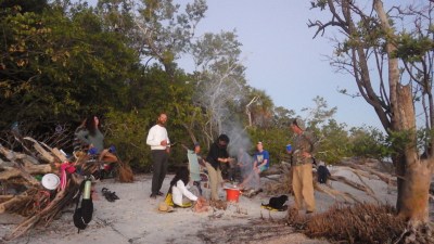
The “Everything Tree” on Panther Key

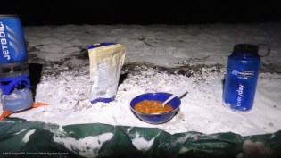
In the bright light of full morning, I sat down to make coffee and breakfast… and had a rude shock. The Jetboil, which had worked perfectly well last night (and in pre-trip tests), now would no longer start.

This wasn’t catastrophic, but it was somewhat serious. You can start a Jetboil with a match.. but I’d brought just a handful of stormproof matches with me.  And I only had freezedried food, which required hot water to cook.  So I’d either have to cut short my trip, or curtail my eating—neither of which seemed ideal.

Normally I’d have been panicky. Well, actually, normally we would have fallen back on Vlad’s rickety stove, which he always packed even after we converted to the Jetboil. But there was no longer a “we”, and Vlad’s stove was somewhere back in New York. So that wasn’t an option.

days-2-to-6

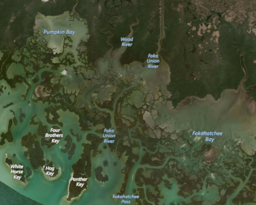
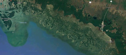
From Pumpkin Bay to Fakahatchee and back

Instead of panicking, I took a close look at the mechanism. It basically works by placing a voltage across the gap between two pieces of wire. Current arcs across, and generates a spark. Close inspection revealed that one of the pieces of wire was encrusted with something, which would preclude any sparking.  I carefully filed it off with my knife, and tested.

It worked!

I sat back on my heels and smiled with satisfaction.  Perhaps it was my imagination, I but I could feel Vlad smiling, too.  I would have morning coffee—and a hot breakfast!

And then…what?

As the water for the coffee boiled, I savored a totally unfamiliar sensation: Complete freedom, with no deadlines or constraints.  I could paddle wherever took my fancy, go for as great or small a distance as I chose.

I could… freepaddle.

pumpkin-bay-edited

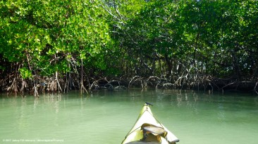
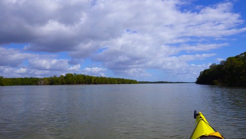
Paddling on the “inside”: Calm, clear, quiet

Russell had mentioned an Indian shell mound up by Pumpkin Bay, and said you could camp there. After inspecting the charts, I decided that would make a nice excursion for today. If I could find the shell mound (and it was indeed camp-able), I’d spend the night there. En route, I’d check out the other keys to see if they held attractive campsites, in case the shell mound didn’t work out.

I had a plan! And options.

I finished breakfast, packed up, and launched.

Paddling “inside” the Ten Thousand Islands is very different from paddling in the Gulf. The water is quieter, and it can feel almost dreamy at times, as you glide along under the mangroves.  Today was warm and calm, and I arrived at the Indian shell mound earlier than anticipated, in the early afternoon.

More accurately, I overshot the shell mound, going far enough up the Pumpkin River to get tangled in overhead branches before turning around, and ultimately sighting the (very narrow) landing spot. After securely tethering the boat to a mangrove, I scrambled up a short rise and into…

…a field of golden reeds, drying in the sun.

It was eerily quiet.

indian-mound-sea-grass

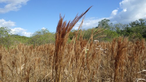
Reeds at the Pumpkin Bay Indian mound

Not that it’s exactly noisy out among the mangroves, aside from the occasional boat motor or croaking sea bird—but this was a special kind of quietness, charged with a low-key, but very real energy.  It was beautiful, and sad, and…not precisely hostile, but not welcoming.

I wandered around taking pictures, trying to decide if I wanted to camp there, and thinking  about the Calusa Indians who had inhabited the area until the mid-1700s. They were by all accounts quite fierce.  I suspected they would not have appreciated my presence overnight.

It was almost as if they were saying to me, “Thank you for appreciating our space, now go home.” Moreover, Russell had told me about hearing a Florida panther scream one night when he had camped there. I was prepared to deal with sharks and gators… but panthers?

Beautiful  as the place was, I wanted to return to the outer islands.  I decided to return to White Horse Key.

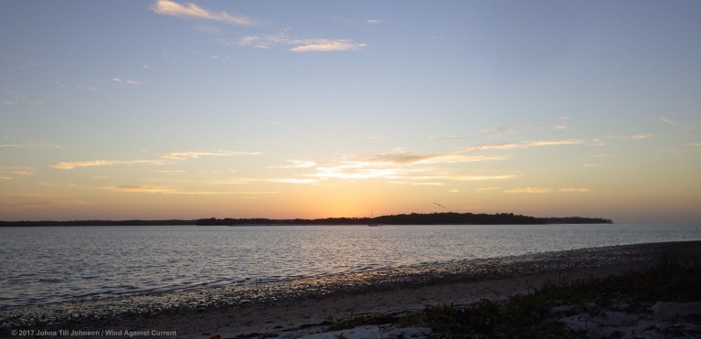
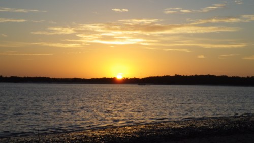
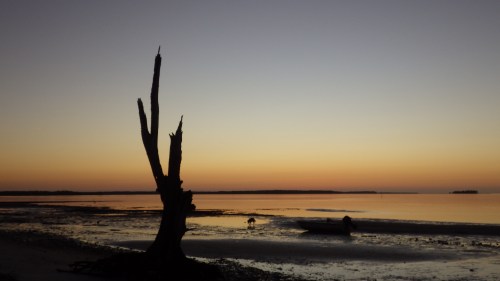
I had no trouble finding my way out of Pumpkin Bay  and arrived at White Horse Key by late afternoon, with plenty of time to make camp, cook dinner, and watch the sun set over my former campsite.

sunset-over-gullivan

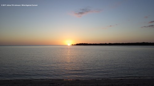
Sunset over Gullivan Key

I fell asleep watching Venus glimmering brightly beside the tiny sliver of the waning moon.

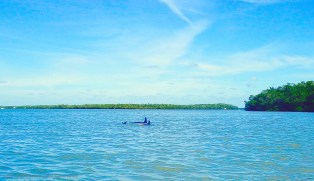
The morning dawned clear and beautiful—and noisy! There was the splash of pelicans striking the water as they fished, oblivious to the presence of the kayaker on the beach. That was complemented by the hoarse sound of dolphins breathing, as they arced above the nearly still water.

Once again there was the question of where to go next. This time, there was a complicating factor: a front was predicted to roll down from the north in two or three days, bringing with it rain, and more critically, wind. I’d need to find someplace where I could shelter—not right away, but soon.

I sipped my third cup of coffee and scrutinized the charts. Today’s trip would involve scoping out the only official “inland” campsite, at Fakahatchee Bay. If it turned out to be a good site, I’d shelter there for a couple of nights. If not, I’d continue on.

Satisfied with my vague plans, I prepared to launch.

A small motor boat had landed on the beach, disgorging a handful of people, clearly day-trippers in short and T shirts. One of them approached me.  He asked how far I was headed, and when I told him I had no idea, he was apparently stunned.

I smiled. Then I pushed my boat out into the waves.

There was a light breeze and satisfying chop. The keys drifted by to the left, first the length of White Horse, then Hog Key, and finally Panther Key.

pumpkin-bay-2-edited

Cloud, sky, mangroves…

As I paddled by Panther Key, I felt a pang of disappointment. It looked like a lovely place to camp, with a series of long, low, beaches facing the Gulf. But it was already quite evidently inhabited: tents (some quite large) were up in most of the campsites, and someone had hung a set of Spongebob Squarepants towels out to dry. Camping there didn’t seem to be an option for later that night, not if I wanted solitude.

There were a few empty spaces, though… and anyone who packed Spongebob Squarepants couldn’t be all bad! Maybe having neighbors wouldn’t be a bad thing.

The day passed lazily.  I located the inland campsite with no trouble, but it was clearly an “emergency only” site, at least for kayakers. Instead of a wide swath of beach, there was a short, steep cliff (too high to bring a kayak up, so the boat would have to be tethered on the water, and gear unloaded). And it was covered with vegetation, with no breeze and the persistent hum of mosquitos, even at midday.

Paddling back towards the Gulf, I once again passed Panther Key, with its strip of inhabited campsites.

There was a small fishing boat out front. I swerved out to sea to avoid its fishing lines. “I’ll try to stay clear,” I shouted to the captain, a wild-haired man of indeterminate age. “Oh I’d love to land a kayak,” he replied jovially. “I could mount it on my wall.”

Chuckling to myself I continued along my way, pulling closer to the shore to inspect the campsites. A little further on I encountered a couple of guys, one heavily sunburned and wearing what appeared to be billowing blue Bermuda shorts. He introduced himself as Mark, and we chatted. It turned out the campsites were part of a group of extended family and friends. The group spent a week here every year, relaxing and fishing. “Come join us for dinner!” Mark said. “We’ve caught lots of fish, more than we can eat!” With that, they ambled off down the beach.

I had to admit, the invitation sounded tempting, especially after nearly three days of freeze-dried food. I pulled the boat up on land and started looking for a suitable campsite.

A few minutes later, two women came by and introduced themselves as Carolyn and Eileen. They, too, invited me to stay for dinner—and suddenly, I was decided. I would-why not?

panther-key-first-campsite

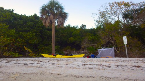
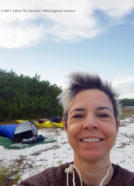
The kayak has landed! First campsite on Panther Key

I dragged the boat further up on land and tethered it to a palm tree. There was a nice snug campsite next to the tree, comfortably large enough for a bivy sack. And a nearby sign would provide just the support I needed to string up the mosquito netting I’d brought with me.

As I unpacked, I listened to the marine radio to monitor the progress of the storm front. The prediction had become considerably more dramatic: from 15 knot winds with 20 knot gusts (which I regularly paddled in), it had leapt to 25-knot winds with 30-knot gusts, which I (and most paddlers) didn’t want to get caught in.

Worse, the front was supposed to hit earlier than expected, by tomorrow night—which meant I needed to be holed up someplace safe by then.

One option was to stay where I was. It was actually ideally situated: facing south (the winds were predicted from the north) with a forest behind me. I mentally stored that idea, then finished setting up camp.

panther-key-friends-and-campfire

Panther Key friends

As the sun fell, I made my way over to the campfire that my new friends had started. It was next to the root ball of a gigantic overturned tree, which they used as a kind of ad-hoc storage closet. Hanging from the roots of the “everything tree”, or tucked between them, were plates, cups, cutlery, and various random articles of clothing (sunglasses, hats, flip-flops).

There were around a dozen people: a husband-and-wife couple (Carolyn and Mark), their friend Rob, Carolyn’s friend Eileen, the wild-haired fisherman (Dave),  his partner,  Carolyn and Mark’s 16-year-old daughter Rachel, Rob’s similarly-aged daughter, their boyfriends (who had brought the Spongebob towels), and confusingly, the boyfriend of Rob’s other daughter, who wasn’t there herself. There was also Rob’s dog, Wolfie, and Mark and Carolyn’s dog Bella.

panther-key-bella

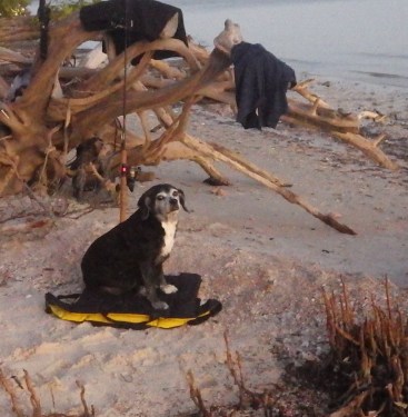
Bella in the seat of honor

Rob offered me a beer, which I accepted gratefully. Even more welcome was Carolyn’s homemade smoked mullet chowder, with freshly caught and smoked mullet and made with potatoes, carrots, and peas. There was also fresh-caught shark, grilled over an open fire.

Warmed by the fire, and delighted by the conversation, I couldn’t believe how happy I was. It had been another entirely unexpected day.

A bit later I said goodnight and headed back to my campsite. Cocooned in my bivvy sack and draped in mosquito netting, I was perfectly at peace. Waves lapped the beach close by, and from farther off came the strains of the guitar music and the faint scent of woodsmoke.  Overhead the stars blazed, and I fell asleep under their benign light.

panther-key-sunrise-wolfie

Sunrise on Panther Key (Wolfie and tree)

The next morning I awoke early to take pictures. I’d already decided it would be a “rest day”: Mark had advised that he and the rest of the crew would be heading out about noon, and I could have one of their campsites. It was perfect for riding out the storm front: I’d move to high ground,under the protective forest, out of the wind and any waves that resulted.

panther-key-second-campsite

Second campsite: Snug under trees!

After helping my friends pack and saying goodbye, I moved camp, battening down the hatches (quite literally!) in preparation for the high winds that were supposed to hit that night.

Instead of paddling, I went for a leisurely swim, then napped in the late-afternoon sun.

After an early dinner, I tucked myself in to await the storm.


Freepaddling in the Ten Thousand Islands: Part One

By Johna Till Johnson

sunrise-over-white-horse-key-edited

Sunrise over White Horse Key

“How far ya headed today?” The speaker was a young man, trendily bald and healthy-looking in the bright morning sunshine.

He and a few other folks had just arrived at the island where I’d spent the night. The rest of his group was walking on the beach through the white powdery sand.

“I have no idea,” I replied.

His mouth opened and his jaw literally sagged. “You have no idea?” he repeated. Clearly, the concept of setting out without a fixed plan and a firm destination wasn’t something that he could comprehend.

“That’s right, none,” I confirmed.

That wasn’t entirely true: I had some idea. I had a chart marked with promising camping locations, and homemade tide charts indicating the optimal time to approach each. But exactly where I’d end up each night, and how far I’d go before I got there—I hadn’t decided. For the first time in my life I was without a fixed plan, other than to stay out in the Ten Thousand Islands for a week or ten days–or however long took my fancy.

Taking your grief into the wilderness is an established literary trope (cf Cheryl Strayed’s Wild). And I’d been desperate to get away from the looming darkness of a New York winter–not to mention to avoid confronting Christmas, which is one of Vlad’s favorite holidays. But I also wanted to find out how well I’d fare on a solo kayaking expedition: Did I have what it took to spend days in the wilderness by myself? Could I find my way? Handle the inevitable emergencies?

And most importantly, could I hoist a kayak onto a car top by myself?

The first step was to make sure I understood the area. The Ten Thousand Islands is a stretch of parkland on Florida’s Gulf Coast that runs south of Cape Romano and north of the Everglades. The name isn’t apocryphal: There are probably at least ten thousand islands—but most of them are mangrove patches, pretty to look at (and home to thousands, probably millions, of birds) but impossible to land at.

google-maps-of-10k-islands

The Ten Thousand Islands

A few of the islands have sandy beaches and are camp-able—the trick is to know which ones, and how to get there. It’s easy to get lost in the mangrove swamps,  where everything you see is a green bubble perched on an expanse of blue-green sea.

Fortunately Vlad had several nautical charts of the area, at different levels of resolution. I selected three to accompany me on the trip (plus a backup). But although they’re important, charts are no substitute for the most critical component of understanding the area: Local knowledge.

To that end, I sat with a friend (Russell Farrow of Sweetwater Kayaks) over a pint or two at one of the many microbreweries in the town of Dunedin.  We discussed the area, and he pointed out several features that weren’t on the charts, including an indian mound at Pumpkin Bay, and many camp-able beaches.

Most crucially, he steered me to a website that listed the tides at several critical points in the Islands. The entire area is extremely tidal, and many routes that are passable at high tide are impossible at low tide. Equally importantly, many sites that appear to be camp-able are not… because the beaches disappear underwater at high tide! So a good knowledge of the tides isn’t just helpful, it’s essential.

After checking online, I faced my first challenge: How to capture the tidal information in a way that I wouldn’t lose it while out on the water? I decided to write them on plastic baggies with a Sharpie. I thought I was brilliant for arriving at this solution, until I found out it’s common among paddlers in the area. Oh well—at least I was headed in the right direction.

tide-charts

Homemade tide charts

Speaking of heading in the right direction, Russell also recommended Calusa Island Marina as a good launching place, with ample (albeit expensive) parking.  I could leave the car there for the duration of the trip.

About that car… the idea was for me to rent a boat at Sweetwater, load it on to my rented SUV, and unload it when I got there. Simple enough, except I’d never put a boat on a car (much less an SUV) by myself before.

boat-on-car

I did it myself!

Vlad and I could handle it together, but I really wasn’t sure I could do it solo. Not only is my strength lesser, but I simply don’t have the height to hoist the boat onto the car.  “We’ll show you how,” Russell assured me.

Sure enough,  they did. And I could! (The trick, it turns out, is using a piece of carpeting to slide the nose of the boat onto the roof—and standing on a stool.)

My courage bolstered, a few days later I arrived at the marina. It took a surprisingly short time to  unload the boat from the car, pack it, and set off without a backwards glance. (A mistake, as it turns out, but that story comes later).

setting-off

Setting off!

I was on the water around 10 AM. The day was warm, but not too hot, with a light wind. I wended my way through the mangrove islands, where the light turned the water green-gold, and headed out towards the open Gulf.

green-mangroves

Green mangroves…

Suddenly I heard a splash, followed by a deep, throaty breath. A dolphin! No, a pair of them! They arced around me, diving and coming up for air, oblivious to the kayaker in the water. Apparently I was paddling over a roiling school of mullet, and the dolphins were enjoying breakfast. It was an auspicious sendoff!

pair-of-dolphins-edited

…and a pair of blue dolphins!


I soon pulled past the last of the keys and turned left (roughly southeast), heading down the coast. To my left were the Ten Thousand Islands. To my right was open water, with the sun sparkling off the tips of the waves.Without any particular destination in mind, I kept going for a few more hours, ticking off the various keys as I passed them, pleased with my ability to track them by compass and chart alone (I had yet to turn on the GPS). Around three PM I decided to investigate potential campsites–although the days were longer in Florida than in New York, darkness still came early. The sun would set at 5:45, and I didn’t want to be caught without a campsite.

When I turned towards the keys, I found I had a choice of two keys quite close together: Gullivan, which wasn’t an “official” campsite, but which Russell had marked as quite camp-able; and White Horse. White Horse was bigger, with a long stretch of beach, and higher ground, particularly on the inside tip. But I could see campers there already: at least two large tents, plus what looked like a sailboat anchored nearby.

Gullivan was empty, and for the first night out, I fancied being by myself. So Gullivan it was!

I paddled around the inside end of the island. Just as on the chart, there was a small curved bay, with a sandy bar protecting calmer water. The sand bar didn’t seem high enough to withstand high tide, though, so I continued around the curved end. There, on the side, facing White Horse, was a long sloping beach, with trees, grass, and high ground behind it. An ideal campsite.

I landed the boat, unloaded the water (the heaviest part of the load was the roughly 50 pounds of water I’d packed, in collapsable Platypus bags, and I couldn’t move the boat myself without emptying it of waterbags), and dragged the boat up on shore.

gullivan-key-selfie

First campsite on Gullivan Key

Then I set up the campsite, on the highest point I could comfortably manage. It was a couple of feet above the highest high tide mark. High tide would hit around midnight, but with luck I’d be well above it. If not—well, there wasn’t any higher land on the island. So I’d better hope for luck.

“I’ll be fine,” I thought blithely.  The wind was brisk, so since I didn’t have stakes, I used the water bags to weight down the tarp. The breeze would ensure no mosquitos. All in all, I was quite satisfied with the campsite.

After a short walk around my deserted island, I broke out the Jetboil and made dinner. To my delight, I was hungry. I hadn’t had much of an appetite in recent weeks, and though my last meal had been a breakfast croissant nearly 12 hours before, I hadn’t felt hungry yet today. But the smell of the freeze-dried spaghetti with meat sauce was enticing, and it tasted even better than it smelled.  I couldn’t have enjoyed dinner more if it had been a meal at the Four Seasons.

After dinner, I snuggled into my bivy sack.  Comfortably cushioned by the air mattress and two pillows (such luxury!), I was protected from the anticipated late-night chill by my sleeping bag, and from any mosquitos by the netting that covered the bivy sack’s opening.

camp-dinner-copyrighted

A five-star meal on the beach!

And I discovered something wonderful: As the night deepened, I could see stars! In an open bivy sack, your face is exposed directly to the sky–it’s not like being in a tent. So through the wispy veil of mosquito netting, I was looking directly up into the spangled heavens. It was a clear night, and the stars glittered brilliantly–including Venus, which hung close and bright to the fading crescent of a waning moon. My last conscious thought was: “I’m sleeping under the stars!” And then I was.

I awoke a few hours later, in the dark,  to the sound of waves lapping the shore. I looked up and there they were—foaming and frothing just a few feet in front of me. Sure enough, just as predicted, the tide had risen—but when would it stop? It was already strikingly close to where I’d camped (though still below the previous high-tide mark). And high tide was still about an hour in the future. What if it came up higher?

What to do? I could trust to my calculations and assume the tide wouldn’t come up much higher. But if I were wrong… I’d be frantically trying to pack the boat in the dark as water sloshed around everything, perhaps pulling my gear out to sea.  I’d done that once before during the Everglades challenge, and I didn’t want to risk it.

The alternative would be to pack up the boat and, since there was no higher ground on my island, paddle across the short stretch of water to White Horse Key. The night was warm and calm, and I’d paddled at night many times. It wouldn’t be particularly risky… but it would be disruptive. Locating a campsite and setting up camp in the dark would probably consume the rest of the night, and I hoped to get some sleep.

I decided to split the difference. I packed up the boat, changed into my paddling gear… and sat and waited, with my headlamp on. The water was still creeping up the beach, higher than it had been when I first awoke. So I drew a line in the sand. If the water crossed that line, I told myself, I’d launch for White Horse.

It was roughly 11:45 when I drew my Rubicon.  High tide was predicted for around 12:30. So I had 45 minutes to go. I sat up and dozed intermittently, turning the lamp on every five to ten minutes or so to see what the water was doing. By around 12:20 the water had stalled… and by 12:30 it was clearly receding. I gave it another 10 minutes or so to be completely certain… then I unpacked the tarp, bivy sack, air mattresses and pillows, and changed back into my sleep clothes.

I snuggled back into my nest with a feeling of triumph. My calculations had been correct! And if they hadn’t—I was confident I could have made it to White Horse without trouble. In just one day I’d managed to get the boat off the car, navigate my way to an unmarked campsite, and survive the tides. I was on my way!

The next morning, I awoke before dawn. I was sleepy but felt impelled to get up, almost as if Vlad were nudging me. He always liked to take pictures of the sunrise, and of everything else in the clear morning light. I tried to resist the impulse, but like Vlad himself, it was overwhelming. I grabbed the camera and unzipped the mosquito net just in time to see the sky brighten over White Horse into a glorious sunrise…

sunrise-white-horse-sailboat-full-sun

The sun rises over White Horse Key… marking a successful night


Excelsior

By Johna Till Johnson

excelsior-edited

72nd St Subway Station-Q Line

What makes photography interesting is the eye invested with feelings. That was the advice I’d gotten on finding my own photographic style. Strive not for esthetic perfection, but for conveying the emotions and narrative of the moment.

Tall order for someone still figuring out how to keep the camera steady enough to focus!

I was game for the challenge, though I suspected it would be an upwards struggle. One problem presented itself when I ventured out on a recent weekend: the world outside didn’t seem to match my feelings. It was a grey day in midwinter, but I was feeling… buoyant.

How—and where—would I find something that would convey my mood?

I took several shots outdoors before I stumbled across the perfect subject: the brand-new 72nd street subway station. Readers of the blog already know that I love subways. And I’m particularly in love with the 72nd Street station, with its high, gleaming arches, still-pristine walls, and glittering, realistic, slightly larger-than-life mosaic portraits.

Yes, I decided, the subway station would be perfect. Especially since I was taking the subway anyway to run my errands.

I had just about finished up a series of  photos when I noticed someone else doing the same thing: A young man in a puffy black jacket carrying a serious camera—with a long, impressive lens—was across the way, apparently preparing for a close-up of one of the mosaic portraits.

He had long hair and a distracted, somewhat hostile, expression. When he caught me looking at him, his eyes narrowed a bit, in that classic New York scowl. I could almost hear him thinking, “Whaddaya looking at?”

I leaned over the railing towards him. “We’re doing the same thing—only you’re a real photographer!” The scowl disappeared and his face lit up with an almost bashful smile. “I’m trying!” he said.

I smiled back and turned to leave.

Then it hit me: That was my shot. I turned around and steadied myself, hoping he wasn’t looking at me. No danger of that: he was leaning backwards against the railing,  carefully studying his subject. Carefully, quickly, I took the picture, then stepped back to frame it again.

It wasn’t until I’d taken a couple different shots that I noticed something I hadn’t previously seen: the word Excelsior in raised lettering on a concrete bar above the staircase. It’s Latin for “ever upward”, and it’s the New York State motto. I hadn’t even known it was there until I examined my photo.

Whoever elected to put it over a staircase obviously had a sense of humor. But I was delighted to discover something new in my favorite subway station—and struck by the appropriateness of the message.

Ever upward, indeed!

Pipes at Grand Central Station

By Johna Till Johnson

pipes-1-edited-3

Pipes at Grand Central Station

Friday morning, midwinter.

O-dark-hundred, as they say in the military: early in the pre-dawn darkness. I’m at Grand Central Station, traveling north for a business event.

I pass by the track where my train is supposed to arrive in 20 minutes. The track is dark, deserted, with no sign indicating an imminent arrival. Plus the track is filled with what looks like junk. In some places there’s barely a walkway for the passengers. Could there be some mistake?

Buying my ticket I ask the booth agent: “Is this really the correct track?” He checks the monitor, nods. So I take my ticket down to the track. Still no sign, but there are now a few guys driving carts up and down, past the piles of junk.

I walk towards the end of the track, my mind and eye trying to make sense of what I’m seeing. Banks of carts. Wire containers. And is that an old office chair standing by itself? Where did it come from, and what is it doing here?

I pass by a brick building with a sign:  Grand Central Station Mailroom. A mailroom, improbably located on a train track?  Who knew?

The building is lit indoors, but empty. The sign on the door says it opens at 7 AM, but it’s not yet seven.  I peer inside. Tables, printers, bins for sorting.

I keep going, towards the darkness of the tunnel at the far end of the track.  The piles of junk thin out, replaced by banks of cables and pipes, soaring into the cavernous darkness overhead.

There’s a conductor at the far end, standing by himself. He’s a young man, trim, with a tired look on his face. I approach him, wonder in my eyes, excitement in my voice. “This is amazing! Is it always like this?”

“Like what?” he asks.

“All this… ” I gesture to the clutter, the pipes, the darkness.

He laughs. “Every day!”

“There’s so much to look at!”

“Yeah… I guess there is…” His voice takes on a wistful tone. “You don’t really notice it when you see it every day.”

I nod, understanding what he means. Then my attention is captured by a perfect arch of pipes, rising into the overhead darkness.

I reach into my backpack for the camera.

“Photography helps people to see”-Berenice Abbott

By Johna Till Johnson

Photographs by Berenice Abbott

pike_and_henry_street_by_berenice_abbott_in_1936

Pike and Henry Street by Berenice Abbott, 1936

It was one of those Facebook memes that occasionally goes around. “Let’s fill Facebook with art! Like if you want to participate, and I’ll give you an artist to post on your Facebook page.”

The poster, David, is a longtime friend with wide-ranging artistic interests and great taste, so I signed up. Besides, we can all use a little art in the dark days of February, right?

David assigned me Berenice Abbott. I’d never heard of her—though even a photography newbie like me immediately recognized some of her iconic NYC photographs. I spent a delighted evening reviewing her life and work and reading her brief Wikipedia biography. If you haven’t heard of her, I encourage you to do so, too–she was one of the great 20th-century artists of the “realist” school. Her quote about photography helping people to see resonates very strongly with me right now, as I work to develop my eye.

A delightful discovery: She developed several cutting-edge techniques for scientific photography, and in fact illustrated a 1958 high school physics textbook (an article about which appeared in Forbes Magazine recently).

Enjoy!

pennstationinteriormanhattan

Penn Station Interior, Manhattan by Berenice Abbott 1936

blossom_restaurant_103_bowery_by_berenice_abbott_in_1935

Blossom Restaurant by Berenice Abbott, 1935


Subways

By Johna Till Johnson

subway-scene-edited

Subway scene February 2017

I love subways. I’m not sure why.

It’s not just how functional they are, how efficiently they take you in minutes to places that would otherwise require hours of travel through traffic-choked streets.

It’s partly—even mostly— because of the way they instantly, magically adjust your experience.  You go down a staircase and in a moment find yourself safely (or swelteringly) out of the elements.

Perhaps there’s music, anything from a violin to a jazz band, interrupted by the blare of announcements and the scream of trains.  Regardless of whether it was day or night outside, cloudy or clear, the light has changed to a steady, unflattering overhead glow.

Shadows seem deeper, edges sharper. Platforms roll off to the side, hiding themselves behind square pillars. And there are people all around, almost all intent on ignoring you.

It’s an alternate reality, a step out of space and time. And when you emerge at the far end, you’re never quite the same person who first entered…