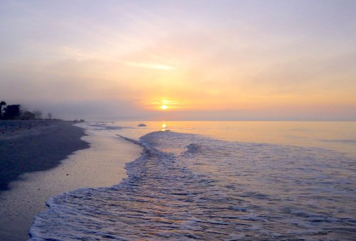
Sanibel sunrise
By Johna Till Johnson
Vlad and I used to joke that in Florida, the wind and current are always against you: the “Florida rules” of kayaking.
So when I planned a circumnavigation of Sanibel Island (13 nautical miles, give or take), I knew better than to apply “New York rules”. In favorable conditions you can complete a circumnavigation of Manhattan (26 miles) in 6 to 7 leisurely hours (averaging around 4 knots). So in theory, you could zip around Sanibel in four hours, plus stops.
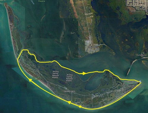
Clockwise around Sanibel Island
But in Florida, you’re lucky if you can average much more than two to three knots, unless you’re doing a one-way run with wind and current consistently in your favor. Even then, Florida conditions have a way of confounding the best-made plans—as I was about to re-discover.
To get around Sanibel Island, I figured a conservative 7 hours, maybe 8, just to be on the safe side. I had picked a perfect day: Not only was the air temp in the 80s, and water temp in the 70s, but the winds were predicted to be a modest 7 mph (6 knots). If I timed things correctly, I should be able to travel up-coast on the flood and down-coast on the ebb.
The first inkling that Florida planned otherwise came the day before my trip, when I was checking the tides to decide which direction to go (clockwise or counterclockwise) to catch the flood and the ebb as I’d planned.
What was this? The mid-day low tide was missing entirely (see tide chart below). That meant no matter what I did, I’d be paddling against the current for at least half the trip. Still, I figured if I launched by 10 AM with the predicted light breeze, I’d make it home by dark.
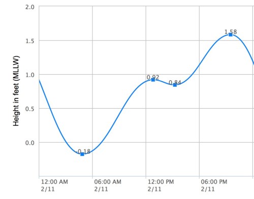
Where did the midday low tide go?
Just to be sure, though, I packed a headlamp… and a backup headlamp… and a GPS… and boat lights. Good thing, as it turned out!
That morning, there was a lively dumping surf on the beach; not big waves, but strong ones. So I was pleased to make a successful surf launch, and set off a few minutes after 10. The sun sparkled off the waves, the moderate breeze was behind me, and I was flying up the Gulf towards Captiva Island, propelled by the rising tide.
In what seemed like no time I reached the bridge separating Sanibel from Captiva. I briefly entertained the notion of continuing on toward the next inlet, but it would add miles to the trip, and if my calculations were correct, I’d be traveling against both the wind and the current soon. So I regretfully decided to turn in as originally planned. (Good thing!)
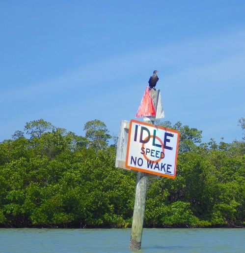
Idle speed, no wake…
As I passed under the bridge, the environment made the usual shift from “outside” to “inside”. Outside—on the Gulf coast—are rolling swells crashing onto long sandy beaches. Inside, the water is placid and peaceful, gently lapping the roots of mangroves.
I paddled past a cormorant blinking lazily on the sun atop an “idle speed” sign. Up ahead… was that a tiny island made up of gray boulders? No, it was a tightly packed flock of pelicans roosting together on a sand bar.
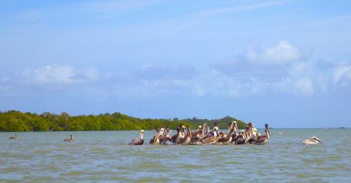
Passel of pelicans
A little further on, I tried to take a photo of some white birds in trees (either ibises or egrets, I couldn’t tell from the distance). But characteristically, though they tolerated my approach without fear, the sight of the camera sent them flapping away.
I rounded the western point of Sanibel Island and began heading east down the coast. Up ahead I saw a fin lazily slicing through the water. Was that a shark? Dolphins typically arc up and down, disappearing for long moments, then reappearing with somewhere else. But this fin was moving in a level horizontal motion…
It wasn’t until I saw a fine spray and heard the characteristic gasp that I was confident the fin belonged to a dolphin. I paddled up close and got a shot, then continued on my way.
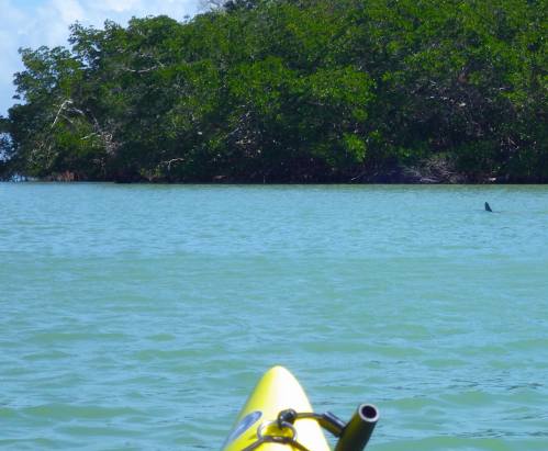
Not a shark
True to my prediction, I was paddling against both the current and what seemed to be a light, but stronger-than-predicted, breeze. I was now moving quite a bit more slowly, and having to work harder at it. Seemingly endless mangrove swamps and keys unspooled to my right. My mind spun free, and for long stretches of time, all I thought about was the next stroke.
Slowly, a line of electrical poles appeared in front of me, linking Sanibel with the mainland. I remembered with a jolt when I’d seen them last: In the middle of the night during the Everglades Challenge. The first traces of the hallucinations that would dog both me and Vlad at night had just begun; I had begun hallucinating a giant George Washington bridge overhead. (Vlad was seeing pop-up decoy ducks on the waves).
Things looked very different in the bright light of early afternoon, but one thing that hadn’t changed was the frustrating slowness of my pace. I recalled how the Ding Darling preserve seemed to go on forever, the mangroves dark against the starry sky. Now they were dark green against bright blue, but it still seemed as though I was inching along.
And there was something else: The wind was picking up. There were small whitecaps everywhere, and the placid water had become choppy. When I caught sight of a flag on a boat, it was usually straight out and flapping crisply. The predicted 6 knot wind had become more like 16 knots.
It was coming from the south, which meant I could shelter from it by staying close to the mangroves—except where there were shoals. As I drew closer to the embayment right before Tarpon Bay, I realized I had to make a choice: Either cut straight across the embayment (and deal with the full force of the wind), or go a couple miles out of my way to keep out of the wind.
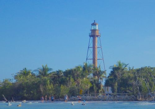
Lighthouse in late afternoon
I decided to cut across.
After a few minutes, maybe half an hour, a boat pulled up to me. “Are you okay?” the captain asked. “It’s pretty windy out!”
I explained that I was fine. (Note to concerned boaters: if a paddler is making steady progress with regular strokes, not attempting to attract your attention, the chances are extremely good that she is fine. Even if she’s alone. Even if she’s a woman!)
Still, it was good of him to check—and he was right, the wind had picked up. Nearly every swell sported a wind-against-current whitecap. It was definitely bouncy!
Slowly, slowly, I pulled across the embayment, and once again approached land. Thankful for the shelter, I set my sights on the next milestone: The Sanibel causeway. Once again, my mind flashed back to the last time I’d seen it from the water: In the middle of the night, surrounded by bioluminescence. Four years ago.
It seemed like another lifetime.
I passed under the bridge without incident, and began pulling towards the lighthouse. The sun was low in the sky by this time, but I was still fairly confident I’d make it home by dark. How far could it be? An hour, tops?
I stopped to take pictures of the lighthouse, where people and pelicans clustered in a happy riot. Then I rounded the tip of the island, skirting the predictable chop at the point.
Home stretch! It would be a straight shot up the beach from here. The only challenge would be locating which, among the seemingly identical condos, was the place I was staying.
The wind had died down slightly, and the current was at last with me once more, but I was still riding swell after swell. Trees, houses, and white sandy beach unspooled to my right. And the sun sank slowly in the sky.
I stopped to take a photo as it sank behind Knapps Point. Lovely, but it meant that for sure, I’d be paddling home in the dark.
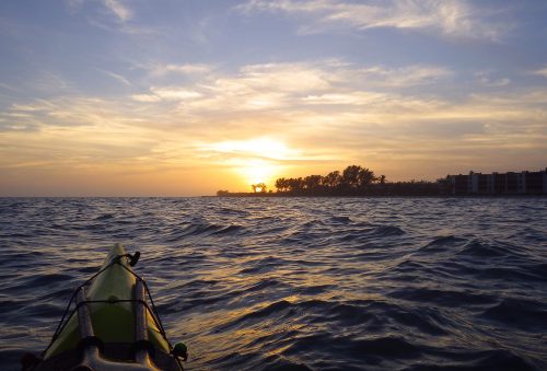
Sanibel sunset
I put on the headlamp and kept going, as the sky faded into purplish dusk. Before long stars began to appear. The moon was waning, last quarter, so I knew better than to expect the help of moonlight.
Slowly the buildings blurred into the night sky. Where was the condo? Even with the headlamp, the silhouettes of the condos seemed frustratingly similar. Which one was mine?
Finally I picked a location that I thought looked good, and did a surf landing.
I dragged the boat up the beach and looked around. There was a sign: Hurricane House. I remembered the location: just a bit short of where I was staying.
Could I walk there, pulling the boat along in the water behind me using the tow rope, as I’d done in the past?
Nope.
The surf was too strong; the first incoming wave swamped the boat. Damn it! Now I had to drag the boat back up the beach and empty it.
After doing that, I launched again and paddled further up the beach. I glimpsed down at my deck, and realized that the wave that had swamped the boat had also washed away my chart. Double-damn it! (Note to self: When making surf landings in the dark, stow chart inside deck bag.)
Oh well. I could always order another one. I kept paddling, into the deepening night.
After about fifteen minutes, I pulled into shore again. Once again, I dragged the boat up the beach. Once again, I looked around.
This time I saw the silhouette of someone—a woman—on the balcony. I asked her for the street address, which she gave me. Figures! This time I’d overshot.
By now it was pitch dark. I got back into the boat and paddled back in the direction from which I’d come. Suddenly the silhouettes to my left began looking familiar: Two palm trees… a big space… and a cluster of palm trees.
This was it! Third time’s a charm. Sure enough, that was the silhouette of my condo.
I checked my watch after dragging the boat up the beach. 7:45 PM. It had taken me nearly 10 hours to travel a dozen nautical miles (including about 45 minutes of going back and forth in the dark).
I could feel the sunburn on my cheeks, and my hands were blistered. And of course, I’d lost a chart.
But I was home. And it had been a splendid paddle, “Florida rules” and all!