Monthly Archives: June 2017

Trip 5: Hudson River, Manhattan to Irvington, October 1999

Text and Photo by Vladimir Brezina

Autumn colors

Saturday, 30 October

Met John and Kathy at Dyckman Street. Put boats together and launched at 11:30 a.m. around the predicted beginning of flood current. Warm for late October. Fog still not burned off completely, but sun gradually appearing. At first light wind from the north, then calm.

Palisades very colorful in the thinning fog. Lunch at Alpine. Stopped at Italian Gardens (waterfall and foliage very picturesque) then crossed over to Irvington. Arrived around 4 p.m.; took out at convenient boat ramp in parking lot by the train station. Briefly saw Kathy’s show at the gallery, then Metro-North train back to New York.

(Note: It’s nice to see that Vlad sometimes went on short and sweet paddles, as well as the longer ones he was known for. And Italian Gardens site was a favored destination for us from Pier 40, though we often failed to make it that far–somehow we constantly managed to underestimate the time required!)

Trip 4: Hudson River, Hudson-Coxsackie Area, October 1999

Text and photos by Vladimir Brezina

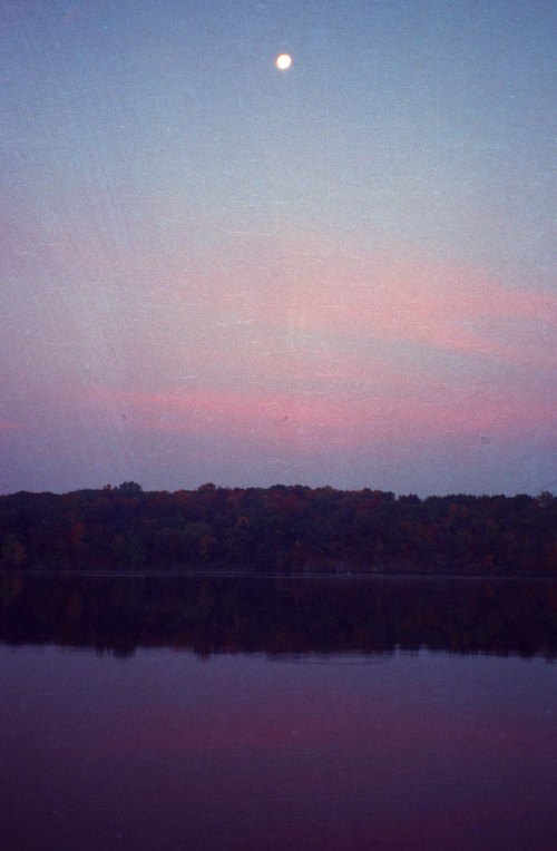
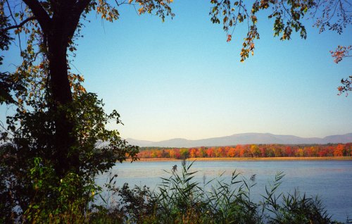
Dawn at Stockport Middle Ground

Friday, 15 October

7:10 a.m. Amtrak to Hudson. Emerged from Penn Station tunnels just after sunrise; views across the Hudson with the rising sun reflected orange, against the clear blue sky, from windows on the New Jersey shore. Beautiful views of the river all the way up to Hudson: fall foliage colors spectacular particularly in the Hudson Highlands; in many places mist rising from the river, with the sun breaking through in dappled patches. Worth the $31 fare just for those two hours. Launched at Hudson around 10 a.m.
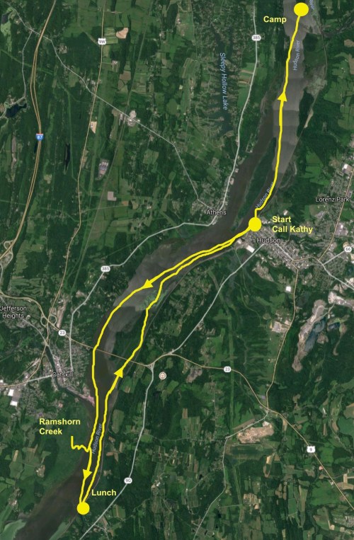
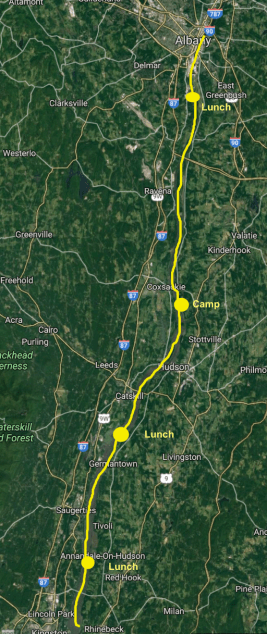
Day 1 Route

Sunny, but distinctly cooler now: crisp fall weather. Water warmer than expected: still possible, mostly, to do without gloves. Southerly wind, ebbing current, quite strong here. Decided to go south along the western shore, photographing the fall colors. Past entrance to Catskill Creek. Large, three-masted replica of an 18th-century (?) sailing ship (couldn’t read name) but with sails furled, motoring, a bit disappointingly, north against the current.

Also a fleet of canoes, probably returning to Catskill from Ramshorn Creek. Paddled slowly up Ramshorn Creek for a while. Very still, winding creek, with muddy banks at low tide; sun behind the screen of leaves, now partially bare. Leaves dropping and floating down on the current.

Then back out into the river and across to the usual lunch place at the mouth of the Roeliff Jansen Kill. South wind now around 20 knots; lots of whitecaps in the main channel. But water around lunch place too shallow just now, so retreated north to Oak Hill Landing for lunch. Fall views of the Catskills.
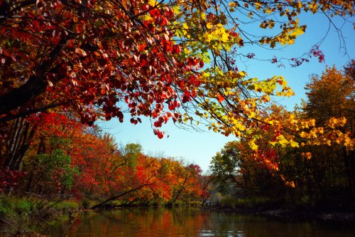
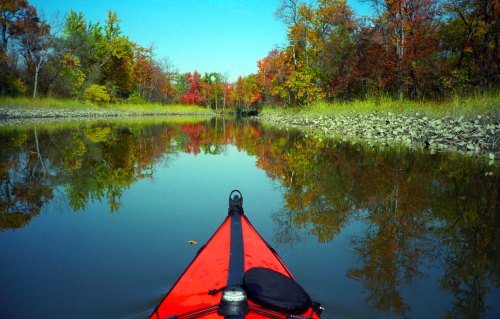
Fall colors

Then north through Hallenbeck Creek back to Hudson. Arrived at the same time as a duck hunter in camouflage outfit, with camouflaged boat, and vigorous complaints against the game laws. (Saw a few other hunters, and many duck blinds everywhere, but almost none occupied. Relieved to hear only very scattered shots.) Phoned Kathy around 4 p.m. Outlook for joining me tomorrow not good.

(Note: It’s very like Vlad to record the hunter’s “vigorous complaints against the game laws”.  He was not a hunter himself, and throughout these logs, hunters emerge as faintly comic characters, in their obsession with camouflage and other para-military gear, which Vlad found amusing. But he also had striking libertarian, if not downright anarchic, tendencies, and would have sympathized with those complaints. )

Current now turned to flood; wind still from the south, though dying down. Evening paddle up to campground at the north tip of Stockport Middle Ground. Halfway up saw, from a distance, a fox (coyote?)-like animal on shore. Arrived at campground just in time to see huge freighter move down the channel to the west against the setting sun.

Night not too cold, probably around 40°F.  New North Face sleeping bag luxuriously comfortable and warm.
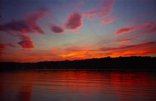
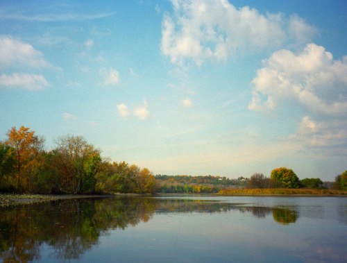
Sunset at Stockport

(Note: It’s about time! The last few trips Vlad has been complaining about the inadequacy of his sleeping bag. It’s fun to watch him grow increasingly interested in kayaking and expedition gear; he was always mechanically minded, but generally appreciated gear for its effectiveness and the quality of its design rather than for the status it might convey.

By the time I knew him, he’d arrived at a gear collection that worked for him, and was less enchanted by every new item. He looked tolerantly on as I went through my own trajectory of fascination with gear.

It was very common for me to remark “I wish I had a gadget that would do (whatever)”… and for Vlad to reply, “I have one of those.” He’d rummage in his overstuffed deck bag (how he ever found anything was a mystery to me!) and pull out a rusty, but still serviceable, whatever-it-was.

Several log posts later we’ll get to read about his discovery of the GPS, and the way it can be useful in tracking one’s speed in different conditions.  That, in turn, leads to a deep understanding of the currents and how they vary—which lies at the heart of Vlad’s legendary knowledge of the NY area currents.)

Saturday, 16 October
Sunrise around 7 a.m. A little chilly, but clothes adequate. Took some pictures of the rising sun illuminating the fall colors on the western bank opposite. Left around 9 a.m., reached Coxsackie around 10 a.m. Very happy to see, from afar, John and Kathy putting their boat together. Sneaked up on them out of the rising sun, got out of the boat and came right up to them without being detected.

Coxsackie very nice launch site: the paved boat ramp (though no floating dock visible), grass, plenty of parking, portable toilets, phone.
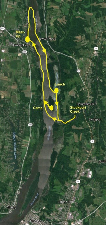
Day 2 Route

North around Coxsackie Island, then across main channel over to eastern shore, south past Nutten Hook, into marshes on either side of Little Nutten Hook. Few herons wading in the shallows, but generally many fewer birds than a couple of weeks ago. Palisade of trees lining the river almost wintery; foliage past its peak, or it may be that the natural tree species here not very flamboyant, just yellow and grey-brown. (Oranges and reds noticeable mainly around houses, probably planted.)

Main river now ebbing but south wind intensifying to a sustained 20 knots.

Waves building to 2 feet in the main channel; we kept to the side but could not get out of the wind. Kathy complained but sticking it out. Lunch at deluxe campground at Gays Point. Dock now out of the water, but there is a sandy beach, grassy area, pagoda, picnic tables, barbecues, outhouses (open), a building (closed) which may have water in season. But all this open to the south wind, so had lunch in sunny and warm clearing in the wood beyond.

Displaced a sunning snake.

Few grasshoppers and butterflies, but insects, like birds, mostly gone. Returning to the boats, we could see wind now 25 knots, treetops swaying and whistling, waves in main channel lengthening, with prominent and very frequent whitecaps.

Continued south past the beaches at the tip of Gays Point and into the channel to the east of Stockport Middle Ground. Somewhat sheltered for a while, then back out into the headwind for the last stretch across the flats to the entrance to Stockport Creek. Here very shallow; ran aground before found proper channel. Four other kayakers, disappearing into the creek. Creek sheltered, but shallow, and with strong current flowing out of it.

Finally, back the same way past Stockport Middle Ground, across the main channel and along the western shore back to Coxsackie. Current now turning to flood; wind dying down somewhat but still strong. Not as rough as it would have been before; waves no more than 2 feet. Moving very fast with the tail wind and current, surfing on the waves. Back at Coxsackie around 4:30 p.m. Car to New York.

Stockport Creek

Trip 3: Hudson River, Albany to Rhinecliff, October 1999

Text and Photos by Vladimir Brezina

View of the Catskills

Saturday, 2 October
7:10 a.m. Amtrak train to Albany, then taxi to boat launch in Corning Preserve just north of railroad bridge. Launched  just before 11 a.m.

Sunny with some high clouds, still reasonably warm. Favorable ebb current through the afternoon, but persistent head wind from the south, at first only 10 knots, but increasing to 15-20 knots at times. Chop increasing in places to 1-1.5 feet, with whitecaps. Water distinctly cool now: brief initial shock on stepping into it.

The route: Albany to Rhinebeck

Foliage colorful now along this section of the river. (From the train could see that it is still predominantly green further south.) Even here still not quite at its peak. In few places a riot of yellows, oranges, and reds (hanging vines, especially, provide bright red accents). Mostly, however, more subtle—one flame-orange branch or tree among shades of green.

Paddled south past Papscanee Island (lunch opposite), then Campbell Island, Schodack Island, Houghtaling Island, Bronck Island (looked for HRWA campground, but couldn’t identify it), Rattlesnake Island, Coxsackie Island. Then crossed to Nutten Hook (here wind gusts up to 20-25 knots, many whitecaps, although waves relatively small), past Gays Point (deluxe campground with dock, grass, water (?) occupied) down to campground at northern tip of Stockport Middle Ground. Nobody there. Campground has picnic tables, barbecues, fire pits, two outhouses. (Picnic tables and barbecues also in a number of the bays of the beach just north, on Gays Point. This area has quite a number of comfortable camping possibilities.) Beautiful views north up to Coxsackie Island, west across the river (arrived at 5:30 p.m., an hour before sunset, so could sit at picnic table and eat dinner while watching the sun set) as well as east, for sunrise.

View from Stockport

Quite warm until sunset, then cooling. But still warm enough in old sleeping bag (with sweatshirt, long pants and socks, thought).

Sunday, 3 October

Some sun visible at sunrise, then clouds moving in and becoming overcast. Light north wind starting up. Left around 9 a.m. Still strong flood current against, so kept to shore of Stockport Middle Ground, then crossed to western shore of river. Started to rain; light to moderate showers for the next couple of hours. But foliage more deeply colorful against the gray.

Took some pictures, but with this camera will probably come out flat without direct sun. Paddled down the western branch of the river past Athens and the lighthouse south of Middle Ground Flats. Overtook group of kayakers out of Hudson going to the marshes south of Catskill. Current now turning to ebb and north wind increasing; making good progress. Becoming sunny again.

Fall colors

Past Catskill to mouth of Roeliff Jansen Kill (lunch around 12 noon), then down main channel to Saugerties (second lunch, 2 p.m.). In shallows and flats along the eastern shore of the river over the several miles before Saugerties, many duck blinds; heard occasional shots. Second lunch on Cruger Island (2:30 p.m.) then down main, western channel and finally east again to Rhinecliff (4:30 p.m.) Amtrak train back to New York City.

Total distance paddled 46+ nm, about 14 hours.

(Note: It’s reassuring to read about Vlad’s pauses for lunch and “second lunch”. Years later he became famous for his ability and desire to spend extended hours in his boat without stopping (20 or more, in some cases). But it’s good to know he didn’t start out that way!

That “second lunch” will also bring a smile to the face of anyone who knew Vlad’s legendary delight in eating. I’ve never known anyone with such an uncomplicated love of food. He wasn’t a food snob. He enjoyed everything from the finest aged steak to McDonald’s hamburgers, but with a definite preference for whole, natural foods.  Perfectly ripe fresh pears and peaches, ice cold from the fridge, were a particular favorite. He ate everything with gusto, eyes sparkling: “This is soooo good!” he would exclaim. )

Trip 2: Hudson Highlands, September 1999

Ardent Point looking south

Text and photos by Vladimir Brezina

Saturday, 25 September 1999

Metro-North train to Beacon. Launched around 2:15 p.m. Sunny, temperature in the 70s. Ebb just starting (spring-tide currents this weekend), light north wind in favor. Water still warm-ish especially in certain places, but clearly cooling. Some floating debris still left from Hurricane Floyd ten days ago, but water generally back to its normal degree of green-gray murkiness; coffee color gone.

Out and back from Beacon, camping at Arden Point

Paddled south along the eastern shore, past Denning Point and Bannerman’s Island, then crossed over to western shore. Ebb current now seemingly 2-3 knots, tail wind intensifying to 15 knots. Moderate following sea.

Paddled into lagoon behind railway under Storm King Mt. Then south past Cold Spring, crossed back east into Foundry Cove and Constitution Marsh. Miniature rapids under the railway on stream ebbing out of the marsh. (The same elsewhere: the strongest currents on the whole river may be those sweeping in and out of these marshes and lagoons with every flood and ebb.) Finally south past West Point and Garrison to Arden Point campground.

The view from Arden Point

Everywhere trees mostly still green, but some kinds already yellowing, noticeably more than last weekend. beautiful contrasts of yellow and occasionally orange or red foliage picked out by the sunshine from the green, against the blue sky. Took pictures. Many orange and black monarch butterflies fluttering over the water on their migration south.

Arrived at Arden Point about 6 p. m, just as sun disappeared behind hills on western side of river. The campsite (south end of Arden Point) has every natural amenity (no man-made ones). Stony beaches either side of a group of rocks elevated over the river with views both south to Bear Mt. Bridge and north to West Point; flat areas, some with moss, on several levels under tall trees just behind. West-facing: great location to view sunset and moon over the river, though cold in the morning as sun does not reach the campsite until some time after sunrise.

At midnight woken by full moon shining brightly right in my face. Somewhat cold in old sleeping bag toward the morning: now definitely need warmer sleeping bag, and warm, dry camp clothes and shoes. A little stove to make coffee or chocolate on a cold morning?

(Johna: By the time I knew him, Vlad never camped anywhere without his trusty stove. We had a mixed relationship: I swore by the Jetboil, and he tolerated it, but secretly held the stove in reserve should the Jetboil fail. However, he really did enjoy coffee in the morning and hot chocolate at night, which I was happy to make. So it makes me smile to see his musings about the “little stove to make coffee… on a cold morning?” )

Eagle alights!

Sunday, 26 September
Left around 8:15 a.m. Sunny at first, then broken overcast. Paddled south with the waning ebb, and moderate tail wind, almost to Bear Mt. Bridge. Went into Popolopen Creek (steep wooded sides above still water, very picturesque) , then into the marsh just north of Iona Island. Many hawks (?) circling overhead everywhere (Johna: Could also have been eagles; the photo here was taken not too far away, over ten years later. ) especially along edge of woods; later saw one capture a pigeon-sized bird in flight, with much squawking. Current now starting to flood. Becoming sunny once more. North back to Arden Point (lunch around 12 noon) then through World’s End. Just before, heard two deep hoots, and an enormous red-yellow ship, followed by a tug, emerged very slowly to turn downriver past West Point. North past Cold Spring, then hugging shore all the way back to Beacon. Now wind from the south, moderate following seas. Shore-line woods very colorful; took many pictures. Many kayakers and canoeists, mostly solo or in pairs, on the water. Beacon around 3:30 p.m.

Trip 1: Hudson River, Rhinecliff to Ossining, September 1999

Text and Photos by Vladimir Brezina

Early morning colors on the river

Note: After Vlad died, I was astonished to discover that he’d meticulously maintained logs of nearly 300 kayak excursions he made, alone and with others, from 1999 to 2011. He only stopped when this blog became the official chronicle of our journeys.

Although they are true nautical logs, with observations on the weather, conditions, and mileage, they are also written in his characteristic style, with whimsical musings and droll asides sprinkled throughout, so they make for surprisingly lively reading.

Best of all, he also worked in the last months of his life to preserve his vast collection of photographs, so I’m able to pair the logs with photographic illustrations of the same areas. They are not necessarily from the same trips (though some almost certainly are). Wherever possible, I’ve attempted to match for season and conditions.

I plan to publish one each Thursday for the next year or so (not all logs are long enough to make into standalone blog posts). I’ve edited the logs minimally; you’re reading almost exactly what Vlad wrote.  —Johna Till Johnson

18-19 September, Rhinecliff to Ossining
Saturday, 18 September

(Editor’s note: Vlad traveled south from Rhinecliff, which is the starting point roughly in Kingston. The Denning Point campsite is marked, as is his destination at Ossining, a bit north of Rt 287 on the map.)

7:10 Amtrak train to Rhinecliff. The train was delayed by the possibility of water and downed trees on the tracks—Hurricane Floyd hit the area on Thursday night—and I was able to launch only around 11 a.m. Sunny, temperature in the 70s, light north wind, calm water. Water very muddy, with swirls of mud, like light unstirred coffee. Visibility only a few inches. Other signs of hurricane: in some places accumulated masses of floating debris, mainly old driftwood and dead branches presumably swept off beaches. Later I saw some downed trees and numerous beached boats.

Just north of Middle Hudson River (Esopus) Lighthouse, I saw a seal. (Although this far up the river the water is completely fresh.) First it was following in the wake of a sailboat motoring in the other direction, then a few minutes later I saw that it had turned and was following me.

I stopped paddling and watched. The seal kept diving and surfacing, poking its head out of the water. Once it arched its back out of the water like a dolphin. It kept to a distance of about 10 yards. I started slowly paddling twards its position while it was submerged to get closer for a picture. I got slightly closer, but then the seal (apparently unable to see underwater because of the mud) surfaced by chance about two feet off the port side. It must have panicked and gone into an emergency dive; all I saw was an enormous splash, like a huge fish jumping, and was soaked with spray. (Another argument for a waterproof camera.) After that the seal did not surface for a while, and then kept to about 30 yards.

Camp at Denning Point

Good ebb current (1-2 knots?) plus tail wind (10 knots?) in favor. Keeping in the middle of the river, I reached Pougheepsie about 2 p.m. Then the current slacked off. I was hoping that with the runoff water the ebb would be prolonged and the flood abbreviated. This was probably the case to some extent, but nevertheless soon when I stopped I found myself unmistakably drifting backward, despite the tail wind. So I continued along the shore.

I reached Beacon about 6:30 PM, then continued to the camp at the southern tip of Denning Island, arriving around 7 p. m., just before sunset. I briefly explored the trails inland, but could not find the grassy area near ruins described in the HRWA guide. So I camped on a level sandy spot, under trees and behind big driftwood logs, just on the point, with good visibility both west across the river and south to Bannerman’s Island. It got dark, lights came up across the river and a quarter moon: bright moonlight, sharp moon shadows, I could almost read.

Outdoor Research bivy sack with Thermarest inflatable pad, on flat, level ground, very comfortable. Good ventilation, quick and easy to set up. (Editor’s note: I have what I believe is that original OR bivy sack, though I’ve upgraded to a newer model for my own use. I very much agree with Vlad’s assessment!)  Old sleeping bag still adequate this time, but probably too light for any significantly colder temperatures. Also too small—need to get larger, mummy-style bag with hood. Need tarp that I can spread out, too, otherwise sand gets into everything.

Morning fog

Sunday, 19 September

Morning somewhat brisk—fall is definitely coming. Mist rising from the river, drifting over with the north wind, but now and again glimpse some blue sky. Took a number of pictures of trees in the mist around the campsite. Left about 8 a. am. Across the Fishkill Creek estuary south from Denning Point, paddled completely surrounded in fog. Took pictures while paddling along the opposite shore: trees emerging from the fog. Bannerman’s Castle.

Cold Spring

South toward Cold Spring, the fog began to lift. Mist and clouds, but now also sunshine and increasing patches of blue sky, dramatic views of the Highlands. Trees still for the most part green, although here and there one already turning. With Bannerman’s Castle, could almost have been Scotland. (Editor’s note: As some readers are aware, Vlad spent several years as an adolescent in Scotland.)

Bannerman’s Castle

Gusts of stronger north wind (15 knots?), some following seas building as always here. Past Cold Spring, West Point with increasing current in favor. Peekskill at about 11 a. m. White beaches of Verplanck (lunch in someone’s homemade hammock overlooking the beach). Across Haverstraw Bay. Lots of motorboats and sailboats criss-crossing the bay.

White beaches of Verplanck

(Editor’s note: The other photos may or may not have been from this exact trip; at least one is not, because it’s a later boat model. However, this photo is almost certainly from this trip; it’s Vlad’s first boat and paddle, and its album caption is “White beaches of Verplanck”—a phrase that appears to be unique to him, and that he seemed to have coined on this trip. )

Now good sailing breeze: onshore breeze building from the south, waves negligible at first but by Croton Point 1-1.5 feet. Ebb current fading too. Making relatively slow progress into the wind. Significant area of higher breaking waves (2 feet) south of Teller’s Point. Boat filling up on water. Effects on handling quite noticeable: boat wallows with and through the waves rather than bouncing over them as usual. Made for the south shore of Croton Point to bail out the water, then across Croton Bay to Ossining. Arrived about 4 p.m. 5:30 train to New York City.

Must seam-seal and Scotchguard deck, shorten paddle-leash and eliminate Velcro paddle attachment.

Whole trip about 50 nm, paddling time about 16 hours.