By Vladimir Brezina

In conjunction with a post on kayak sailing, here’s the story of my very first kayak sailing trip, way back when in September 2002… I and Mark Starr sailed in a double kayak from Stonington, Connecticut, clear across Rhode Island, through Vineyard Sound and Nantucket Sound, to Chatham, Massachusetts, a distance of about 100 nautical miles.
This was actually a consolation trip. Mark’s original plan was to sail the kayak to the edge of the continental shelf, to a point in the open Atlantic Ocean about 100 miles south of Montauk, New York. This would have been more than twice as far and taken several days. He wanted to see where the blue depth contour lines bunch together so dramatically on the chart… I completely agreed and we were all set to go, but one after another hurricane threatened and finally Mark’s wife Susan, although entirely supportive of her husband’s other adventures, put a stop to this one, probably wisely.
So instead we sailed along the coast. Here’s the story of our sail as published in the May/June 2003 issue of ANorAK, the Journal of the Association of North Atlantic Kayakers. (After I published this and a couple of other stories in ANorAK, the journal folded—hopefully not cause and effect! But I believe the Association still exists in vestigial form.)
________________________________________________________
A Kayak Sail along the New England Coast
On a long kayak trip, I always want a good tail wind behind me to push me along. So how much faster would the miles fly by if I could put up a sail? Last September, I had a chance to find out. Mark Starr told me he needed a partner to accompany him on a long trip in his double sailing kayak. Mark was not put off by my lack of sailing experience, and he was polite when, during a preliminary test-sail in Long Island Sound, we kept turning in circles because I automatically pressed on the rudder pedals as I would have done in my own boat, where the rudder cables are reversed. With a calm, courteous manner, Mark was very obviously an expert kayaker and seaman. (And boatbuilder: his book on Greenland kayak construction was reviewed in the last issue of ANorAK.) He had done a similar trip before successfully, although his previous partner was evidently not returning for a repeat performance.
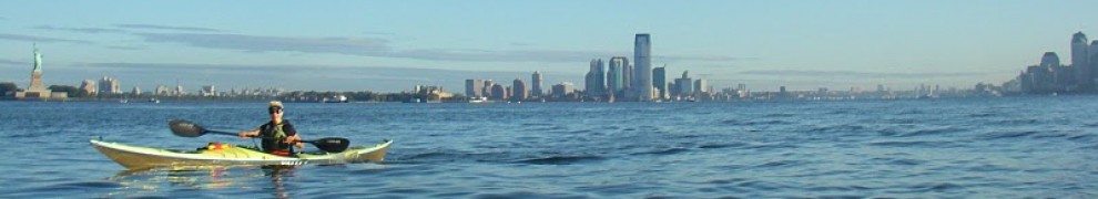
So on a Saturday in mid-September, Mark’s wife, Susan, drove us and the kayak to a little beach on the point of Stonington, CT. The kayak was a 19-foot white fiberglass Wilderness Systems Seascape with a Balogh Batwing sail rig. We assembled the sturdy aluminum mast and cross bar holding the leeboard and inflatable blue outriggers, raised the green and purple sail, waved to Susan, and pushed off the beach at 7:15 a.m.

Mark pondering the eternal pre-launch choice: since one of the two will be, is it better to be too hot or too cold? As it turned out, we were first hot, then cold.
I was in the front cockpit, Mark was in the rear steering and sailing. But there was little wind. We paddled with fast strokes but, as always in the first minutes of a kayak trip while still on land time, we seemed to be moving disappointingly slowly, and it seemed like very hard work. If it was going to be like this all day… We found it hard to settle down to any kind of paddling rhythm because we kept hitting the outrigger cross bar with our paddles. As soon as either of us forgot to make a stroke very short, his paddle clattered off the cross bar with a painful jolt. Thus, with irritated exclamations and, later, curses, we made our way out between the Stonington breakwaters, around Napatree Point, and east through a flock of fishing boats under Watch Hill to emerge into Block Island Sound.
We continued east along the Rhode Island coastline, a couple of miles off the beach. The day was growing warm with sun filtering through high clouds and haze over a pale, gently undulating sea. We were both warmly dressed—I was wearing a wetsuit—and beginning to regret it. But now we gradually started to feel some wind, at first just refreshing little gusts of coolness but soon strengthening enough to move the boat. In an hour we found that when we stopped paddling, we were sailing along at three knots. (I had my GPS on to monitor our speed.) We resumed paddling to maintain our speed above five knots but it was good to know that we wouldn’t, after all, have to do all the work ourselves. The monotonous low coastline unfolded away to port; somewhere to starboard, Block Island was invisible in the haze. Around noon, we crossed the wake of a Block Island ferry just off Point Judith.

The coast on our port side now fell away north toward the peninsulas and bridges of Narragansett Bay in the far distance. Our course, however, lay east, across 25 miles of open water to the as yet invisible Elizabeth Islands and Cape Cod. Before proceeding, we switched cockpits. Mark turned the boat into the wind, then crawled forward along the deck on one side of the mast while on the other side I slid backward into the rear cockpit. Now I was sailing the boat! I experimented for a while to find the optimal angle of the sail to the wind, before I tied off the sail so that I could continue to paddle along with Mark. But paddling was becoming unnecessary now, even unproductive with anything other than extremely fast, shallow strokes, as the speed of the boat snatched the paddle away as soon as it entered the water. Although the southerly wind was not much stronger than ten knots yet, that was already plenty for our light boat. Three-foot seas were developing, and we were racing before them at seven knots. When the boat tilted down each quartering wave before taking off, this was rather alarming at first because instinctively I tried to apply a corrective lean, with no effect whatever in this outriggered boat. It took a long time to learn to ignore this instinct. The rudder, by contrast, demanded constant attention to hold our compass course across the waves. The high sun sparkled off the tossing blue waves, here and there momentarily breaking out in white foam. Spray flew off the outriggers as we rushed through the water.
After some time we put down our paddles to eat lunch, while we continued to sail along at five knots. The sky was beginning to cloud over to the south, the wind was still increasing and four-foot waves were appearing. We took this opportunity to put on our hooded anoraks, as it might be difficult to do it later.
Mark suddenly pointed out a pale band low on the horizon, barely distinct from the sea and sky. This was Cuttyhunk, the outermost of the chain of the Elizabeth Islands. Later we also spotted a tiny Gay Head, the nearest point of Martha’s Vineyard, poking above the sea. Both were still many miles distant. We resumed paddling, and by 4 p.m. we were passing the tall red column of Buzzards Tower, its base ringed by white breakers. It felt strange to reach Buzzards Tower by kayak from seaward. From there we followed the edge of the Sow and Pigs Reef toward Cuttyhunk. The wind was now blowing at 15 knots and waves off the open ocean were piling up on the reef. We watched as the confused crests combined and recombined, once or twice leaping up to perhaps seven feet. In our outriggered boat we could afford to view these waves with philosophical detachment. Then we drew even with Cuttyhunk and the seas subsided. We sailed quietly up Vineyard Sound, between the Elizabeth Islands and Martha’s Vineyard.

View from the rear cockpit, sailing into Vineyard Sound. Cuttyhunk is on the horizon.
At 6 p.m., the sun disappeared behind western clouds in a blaze of red. Before the light failed, we switched cockpits once more. Then a dark night fell. It was soon pitch black save for the periodic white flash of Nobska lighthouse ahead, guiding us up the Sound, and a few shore lights on Martha’s Vineyard. We had no lights on, but held our headlamps ready. We used them once to illuminate our sail when the green side light of a passing fishing boat seemed to be getting too close. Then we had to shout very hard to convince the fishermen that we did not need to be rescued.
Finally, the flash of Nobska began to fall off to port as we started to make our turn east at the top of Vineyard Sound. Ahead the lights of Falmouth, until then hidden by the dark mass of Martha’s Vineyard, came into view. A dim moon-glow appeared on the water for a time, revealing the shadowy forms of following seas all around. Paddling like mad, we surfed a few of the waves. Mark whooped in the back. But although we were racing through the water, we were not making much progress over the ground. The red lights of a tall radio tower seemed to be in the same position forever. We were in the grip of a contrary current.
We knew that the current would turn eventually and, in our comfortable sailboat, we could be patient. Feeling ourselves to be safe on a benign shore, with clusters of street lights reflecting off the black water and car headlights flashing out not a mile away, we relaxed. We did not look at our watches and gradually lost the sense of time. We simply sailed on, paddling at intervals now also to ward off the increasing night chill. The hours passed. At some point, almost unnoticed, the radio tower conceded defeat and slipped astern. New clusters of lights along the Cape Cod shoreline came into view and passed by.
To starboard, the lights of Martha’s Vineyard had long since been replaced by an inky mass, distinctly blacker than the rest of the sky—storm clouds over Nantucket. A few rain drops fell. The southerly wind strengthened and the waves grew. Out of the darkness, grey foaming breakers rolled and crashed over the boat. One big wave I remember particularly. I had just carefully unwrapped a precious piece of chocolate and raised my hand with it to my mouth when the wave struck. Mark told me later than from the rear cockpit he watched me completely disappear in a cloud of spray. When the water cascaded away and I completed my motion to pop the chocolate into my mouth, the chocolate was dripping with salt water. We both burst out laughing. But at other times we were not laughing. The boat bounced wildly across the waves, sliding down each one to dig in its short bow so that water flooded across my spray skirt from the lee side—the water, at least, was bathtub-warm—then racing away before being slammed from the weather side by the next breaker. Increasingly, the boat felt out of control. Mark was thinking about reefing the sail.
Before the trip, Mark had prepared navigation charts and carefully planned our course. But we were no longer paying close attention, and the wind had pushed us far inshore. We were racing along when suddenly I saw the darkness in front of the boat solidify into a wall. After a horrified moment, I shouted “Wall! Breakwater!” In fact it was Gammon Point, which projects out two miles from the general trend of the coast. I have been there since in daylight and it is a low, pleasant, undramatic peninsula, but now at night it was menacing. Mark instantly turned the boat around and we paddled as hard as we could to escape. The area is full of exposed rocks, but we managed to pass through without hitting or even seeing any of them. At a red buoy which we presumed marked the limit of the danger zone, we turned east again. Another necklace of shore lights, before hidden by Gammon Point, stretched into the distance. The furthest of these should be our destination, Chatham, MA.
At 3 a.m. we finally zipped a reef into the sail. The operation went smoothly and the boat now moved more easily, albeit more slowly, through the waves. To keep our speed up but even more to keep warm, we paddled in short, hard spurts. We reached and passed each cluster of lights that we half-hoped was Chatham, but each time further lights appeared ahead. Imperceptibly, though, the wind was becoming less strong, the waves less violent, and eventually the black water grew still as we sailed into the protected northeast corner of Nantucket Sound. We passed shoals on which the waves were still breaking, but they no longer had the power to reach us. In front of us, light beams swept across the low clouds like searchlights, away from us for these were lighthouses already at the outer edge of the Cape, shining out into the open Atlantic.
At 5 a.m., we turned into the wind and switched on our headlamps to study the chart. Red and green buoys winked here and there in the darkness. The lights of two predawn fishing boats emerged carefully through a narrow channel. We were at the entrance to Chatham Harbor, but with shoals and the shore unseen all around and the exact location of the Chatham boat ramp uncertain, it was necessary to wait for daylight. We prepared to hold our position where we were, but, as we began to make out the dim outlines of what lay around, we discerned that we were ten feet off a beach. A couple of paddle strokes later, the bow crunched up on land. This was by now a strange sensation. Crawling out of the kayak, we both stumbled around on the sand like drunks before our legs regained the strength to bear us. Then we walked along the beach, suddenly relieved and happy to have arrived. When a grey, overcast dawn came, we sailed through the host of boats now revealed everywhere at anchor and, asking direction of early Sunday fishermen just heading out, found the boat ramp in a corner of the harbor.
On land, the craft that had skimmed so lightly over the waves was a heavy, ungainly creature. It lay surrounded by the wreckage of its disassembled rig and drybags spilling out of its hatches. We waited for rescue. Susan, evidently used to such missions, arrived at 11 a.m. and was happy to see her husband undrowned. She drove us and the kayak back to Stonington through the rain while Mark and I dozed in the car.
So, is a sailing kayak faster? No, and yes. We paddled and sailed 100 nautical miles in 22 hours, at an average speed of 4.5 knots—not very different than paddling without a sail. But there is much to be said for knowing that your boat will carry on steadily whether you paddle or not, while you watch the sea, eat, sleep, keep warm—simply live, which at times may take all your energy—for days if need be.


Pingback: Travel Theme: Tilted | Wind Against Current
Hi,
How long you take the long trip along the New England Coast? Only by paddling?
Your trip is very impressive. I wish i could do.
Thank you so much for your sharing.
LikeLike
Thanks! It was mostly sailing, but with paddling as well when the wind was weak, and to keep warm!
LikeLike