Tag Archives: Satellite Images

Zooming in on Planet Earth

By Vladimir Brezina

I just can’t resist those satellite images!

Following the Blue Marble and its more recent recreations, there are now some amazing new images of the Earth out on the Internet.

These images were taken by cameras aboard Elektro-L 1, a  Russian weather satellite in a geostationary orbit ~35,700 km above the Earth’s equator. Every 30 minutes, the satellite’s cameras create a 121-megapixel image at an unprecedented resolution of ~1 km of the Earth’s surface per pixel. The images were posted on the Planet Earth website by James Drake, who obtained them from the Russian Federal Space Agency and stitched them together into various time-lapse movies.

Some of the movies, such as the one above, attempt to show approximately true color. Others use infrared wavelength information to highlight vegetation in orange.

Various movies, zoomed in on different geographical regions, are available on YouTube or at the Planet Earth site, which also has interactively zoomable images that offer some sense of the true resolution of the images (the movies have much lower resolution for posting on the web) and a beautiful image gallery.

News reports with more information are here and here.

“When I see these images, I perceive the planet we live on as incredibly beautiful, interconnected and alive,” Drake said. “They show the Earth for what it is, a spinning orb of metal and rock with a thin surface layer of unimaginable complexity. The fluid water and air that cover our planet are filled with intricate self-replicating fractal patterns called life. What is happening on this planet is absolutely extraordinary!”

Slightly disconcerting, however, are the ads served up by Google with the YouTube videos:

“The End-Time is Here! 2008 was God’s last warning. 2012 is economic collapse and WWIII. www.the-end.com. Ads by Google.”

And another about UFOs…

Is there something Google knows that planetary engineers and scientists don’t?

Since these ads are personally targeted, though, watch the videos and see what Google has in store for you!

The Bright Lights of the Big City from Space

By Vladimir Brezina

.

[For best viewing, click on the HD icon in the top right corner, then expand to full screen by clicking on the icon in the bottom right corner]

Video courtesy of the Image Science & Analysis Laboratory, NASA Johnson Space Center:

This video was taken by the crew of Expedition 30 on board the International Space Station. The sequence of shots was taken January 29, 2012 from 05:33:11 to 05:48:10 GMT, on a pass from just southwest of Mexico to the North Atlantic Ocean, northeast of Newfoundland. This pass begins looking over Central America towards the Gulf of Mexico and the southeastern United States. As the ISS travels northeast over the gulf, some southeastern United States cities can be distinguished, like New Orleans, Mobile, Jacksonville, and Atlanta. Continuing up the east coast, some northeastern states, like Washington, D.C., Baltimore, Philadelphia, and New York City stand out brightly along the coastline. The Aurora Borealis shines in the background as the pass finishes near Newfoundland.

And notice the firmament of fixed stars unchanging above…

This is just one of the many amazing videos at this site.

Circumnavigating Monomoy

By Johna Till Johnson
(With additional text, charts, and photos by Vladimir Brezina)

This happened in July 2011.

The day dawned clear and bright, and we were excited: This was the day we were going to circumnavigate Monomoy Island. Located at the “elbow” of Cape Cod, Monomoy juts out some eight miles, dividing Nantucket Sound from the Atlantic Ocean. It offers a nice spectrum of paddling opportunities: The protected, shallow water of the Sound on one side, and the deep swells of the Atlantic on the other.

And then there is Monomoy Point, the very end of the island, where the two waters meet.

“Kayakers have died there,” Vlad informed me cheerfully over breakfast.

Continue reading

The Blue Marble

By Vladimir Brezina

Manned missions to Mars and colonies on the moon seize the imagination, at least of Presidents and would-be Presidents :-). Everyone else knows that these are dreams, half-baked, arguably pointless, and certainly unrealizable any time soon (unless it be by the Chinese).

But, in the meantime, NASA has been steadily adding to, perfecting, and using for a huge variety of scientific missions its workaday tools, its fleet of unmanned satellites. Some of these look outward into space.  But many orbit and look down on the Earth itself—and generate all kinds of fascinating and beautiful images.

This past week, NASA released two new images of the Earth as the iconic Blue Marble—the blue planet, seen in its entirety, against the vast blackness of space.

These images were each stitched together from a number of partial images taken during multiple orbits of the Suomi National Polar-orbiting Partnership (NPP) satellite. While the satellite was orbiting the Earth at an altitude of only 512 miles, the composite images appear to originate from an altitude of 7,918 miles. At the same time, they have very high resolution—the original images, with 8,000 x 8,000 and 11,500 x 11,500 pixels respectively, can be downloaded here and here.

As of February 2, 2012, the Western Hemisphere image had been viewed on Flickr over 3.1 million times, “making it one of the all time most viewed images on the [NASA Flickr] site after only one week.”

But that is still nowhere compared to the popularity of the original Blue Marble photo, a single image taken on December 7, 1972, from an altitude of about 28,000 miles by the crew of Apollo 17 as that spacecraft was on its way to the moon. By now, this must be one of the most widely seen and reproduced photos of all time:

Images such as these—and even before they came into being, science fiction writers’ imagination of what they would be like—have moved and inspired many:

Suddenly, from behind the rim of the Moon, in long, slow-motion moments of immense majesty, there emerges a sparkling blue and white jewel, a light, delicate sky-blue sphere laced with slowly swirling veils of white, rising gradually like a small pearl in a thick sea of black mystery. It takes more than a moment to fully realize this is Earth . . . home.

……………………………………………………………..Edgar Mitchell

And they may have convinced some hold-outs that the Earth really is round… although, as the secretary of the Flat Earth Society remarked on seeing such photographs, “It’s easy to see how a photograph like that could fool the untrained eye.”

The 2011 Hurricane Season in 4.5 Minutes

By Vladimir Brezina

Today, November 30, is the last day of this year’s hurricane season.

Hurricanes don’t know that it’s the last day of the season, of course, and in some years they’ve continued well past this date. The hurricane season of 2005, for example, lasted into January 2006; there were so many tropical cyclones that year—among them Katrina and Wilma, respectively the costliest and the most intense Atlantic hurricanes on record—that the prepared names were all used up and six Greek-letter names had to be used.

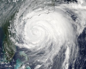
This year, we are only up to Tropical Storm Sean, so far. This time-lapse satellite-image video compresses the entire 2011 hurricane season into 4.5 minutes. Nothing really striking happens until half-way through the season when the impressive bulk of Hurricane Irene moves up the East Coast of the US… But the time-lapse format does give a powerful impression of the swirling of the weather systems and the recurved paths of the storms—the Coriolis force in action!

Where We Like to Land on Sandy Hook

By Vladimir Brezina

Sandy Hook, NJ, a long thin finger that reaches out across the Lower Bay toward New York City, is an irresistible destination for a kayak trip from the city. But once Sandy Hook is off the bow, where to land?  The perfect landing site can be elusive.  Landing is nowhere actually difficult on Sandy Hook—there is a broad sandy beach almost all the way around (although the ocean side can have significant surf).  But in most places it’s a featureless beach, offering no shade in the summer nor shelter from the wind in the winter. Parts of the beach may be off-limits for one reason or another.  And besides, we want to have lunch in a picturesque spot, rich both in local sights and sounds and views of the landscape.

There is such a spot on Sandy Hook. A mile and a half down the bay side, right on the beach, there is an overgrown hillock—almost a little island, no more than a few hundred feet across, that is cut off from the rest of Sandy Hook by a salt marsh that floods at high tide.  That’s where we like to land on Sandy Hook.

Continue reading

Irene and Lee Have Left Quite a Mess in New York Harbor…

By Vladimir Brezina

These tropical storms have certainly stirred things up! Hurricane Irene came through ten days ago and deluged the entire region, and a couple of days ago Tropical Storm Lee repeated the performance. This morning, looking out of the window on Manhattan’s Upper East Side, we saw a strange sight in Hell Gate…

Continue reading

But It’s Not 2012 Yet!

By Vladimir Brezina

I thought we had a few more months until the end of the world

But this week we’ve seen a scenario unfold that is straight out of a Hollywood end-of-the-world movie. After Tuesday’s earthquake, we now have Hurricane Irene bearing down upon us. It seems determined to devastate the entire East Coast of the United States. Millions of people are fleeing for their lives, entire cities are grinding to a halt, awaiting the deluge…

Continue reading