Tag Archives: Weather

I Used to Hate Spring…

By Johna Till Johnson
Photos by Vladimir Brezina

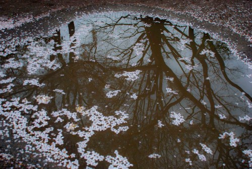
April puddle

April is the cruelest month, breeding
lilacs out of the dead land, mixing
memory and desire, stirring
dull roots with spring rain.

—T.S. Eliot, The Waste Land

I’ll admit it: I used to hate Spring.

Why “admit”? Because from what I can tell, most people are thrilled by lengthening days, soft fragrant breezes, and the sight of new flowers pushing up through the fresh grass.

In New York, Springtime is especially noteworthy. Everyone takes to the parks. Lovers canoodle. Pets frolic. And we walk around with goofy smiles and say unexpected things to each other, like “Please,” and “Thank you” and “After you!”

So what’s not to love?

Continue reading

Thunderstorm over the Gulf at Sunset

By Vladimir Brezina

Seen from St. Pete Beach, Florida, August 2013.

DSC_0100 cropped smallDSC_0102 cropped smallDSC_0130 cropped smallDSC_0120 cropped smallDSC_0131 cropped small

Sandy Saga, Part 4

By Vladimir Brezina and Johna Till Johnson

<— Part 3

Even rats drowned

Sandy’s gone.  She’s now somewhere to the northwest of us, passing into Canada, still producing wind, rain, and snow. If last year’s storms Irene and Lee are any guide, the heavy rain and flash flooding will be devastating, particularly in hilly areas.

But here in New York City, Sandy is over. Her consequences, however, are another matter. First, the good news: Not all that much rain fell in the city (though exact statistics are hard to come by at present with many of the relevant internet sites down). The extreme wind—when we had to cower in the bedroom—only lasted from about 6 to 8 p.m. on Monday as Sandy came ashore, a little to the south of us, near Atlantic City, NJ. Then the winds diminished steadily through the night. Yesterday there were still some sharp gusts, but this morning there is little wind, the clouds are breaking up, and it’s becoming sunny. The rain and wind were over much sooner than anticipated.

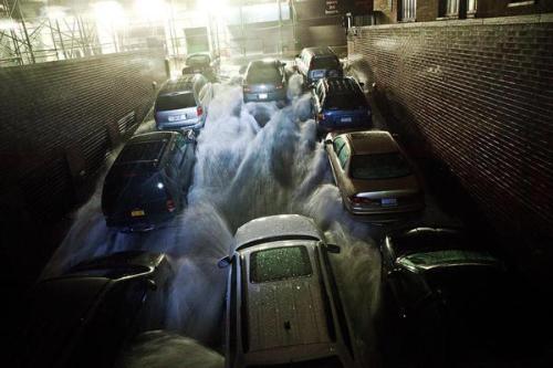
Cars float in a flooded below-street-level parking area in New York’s Financial District on Tuesday (photo by Getty Images)

The bad news, of course, is that the storm surge followed the worst predictions. Coinciding unfortunately with the time of high tide, “water levels in Battery Park on the tip of Lower Manhattan rose to 13.88 feet at 9:24 p.m Monday, smashing the record high of 10.02 feet set in 1960 during Hurricane Donna,” the National Weather Service reported. As we’d feared, last year’s Irene was just a mild preview.

As a result, New York City is crippled.

Dark Manhattan (photo by the New York Times)

Power outage in Manhattan on Monday (photo by Allison Joyce/Getty Images)

Since many of the seawalls around the city are just a few feet high, the storm surge flooded many low-lying areas—notably Lower Manhattan. The water knocked out electrical power and flooded tunnels and the subway, many parts of which remain flooded. Especially as the salt water has probably ruined a lot of equipment, recovery will take days if not weeks.

Lower Manhattan will probably remain without power at least through the weekend. Cell phone service is spotty. Many subway lines are out indefinitely, though on a positive note, some lines—including our lifeline, the number 6—are to resume service along sections of track that were not flooded tomorrow. Buses are running, but slowly and erratically, since many streets are gridlocked with traffic.

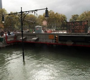
The Brooklyn Battery Tunnel is flooded with about 12 feet of water Tuesday after a tidal surge caused by Hurricane Sandy (photo by Getty Images)

This evening’s Halloween Parade has been canceled. The New York Marathon, scheduled for Sunday, is still on, although skeptics fear that the difficulties of transporting so many people through the city will prove insuperable.

But it could have been much worse—and in many places outside the city, especially in coastal New Jersey where Sandy came ashore, it was.

Continue reading

Sandy Saga, Part 3

By Johna Till Johnson and Vladimir Brezina

<— Part 2

Monday 10/29/12, 11: 30 PM:

From the National Weather Service earlier this evening:

NATIONAL WEATHER SERVICE DOPPLER RADAR INDICATED WINDS UP TO 110 MPH BETWEEN 1500 AND 3000 FEET. SOME OF THESE VERY STRONG…DAMAGING
WINDS WILL OCCASIONALLY REACH THE SURFACE…PRODUCING GUSTS OF
70-90 MPH ACROSS THE NEW YORK CITY METROPOLITAN AREA…

GUSTS OF THIS MAGNITUDE WILL DOWN NUMEROUS TREES…INCLUDING LARGE
ONES. HIGH RISE BUILDINGS ARE ALSO SUSCEPTIBLE TO DAMAGE WITH
THESE GUSTS. PERSONS ARE URGED TO REMAIN SHELTERED IN A STURDY
BUILDING DUE TO THE THREAT OF FALLING TREES…LARGE LIMBS AND
FLYING DEBRIS.

They weren’t kidding about the winds. Thank heavens we’re not at 1,500 feet, but we are in a HIGH RISE BUILDING! Even on the 17th floor—a couple of hundred feet off the ground—the gusts are fierce and very loud. The window frames appear to be flexing, which is disconcerting. Occasionally the whole building rattles, all 30 floors of it. When an unexpected gust slams into it, we are tempted to take refuge in the bedroom and pull the sheets over our heads.

Instead, we take heart and, while we still have power, are roasting a chicken with red cabbage…

The headlines being updated every few minutes in The New York Times tell the catastrophic story elsewhere in the city:

  • More Than 9,000 Flights Canceled So Far
  • Crane Collapses on West 57th Street
  • Power Losses Cascading as Storm Descends
  • More Area Bridges Are Closing
  • Building Facade Collapses in Chelsea, N.Y.C.
  • Con Ed Shuts Off Power to Lower Manhattan
  • Cars Floating on Wall Street
  • Record Water Level at Battery, With Higher To Come
  • Lady Liberty Goes Dark
  • First N.Y.C. Fatality
  • Subway Bridge to Rockaways Underwater
  • 250,000 Without Power in Manhattan
  • New York’s 911 System Overloaded
  • Flooding in Tunnels and Subways
  • Dangerous Water Levels at Nuclear Plant
  • Explosion and Flooding Knock Out Power

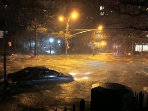
Lower Manhattan, October 29, 2012 (photo by Hurricane Sandy)

Floodwaters rush into a subterranean parking garage in the financial district, October 29, 2012 (photo by Rationalist)

Much of Manhattan is now without power (photo by Rationalist)

Another catalog of the bad news is here:

Hurricane Sandy sent floodwater gushing into New York’s five boroughs, submerging cars, tunnels and the subway system and plunging skyscrapers and neighborhoods into darkness.

The storm shaped up to be among the worst in city history, rivaling the blizzards of 1888 and 1947. Two deaths were reported in Queens and more than 670,000 were without power in the region as of 11:30 p.m., according to Consolidated Edison Inc. The company cut electricity to some areas to save its equipment and a transformer exploded at a plant on 14th Street, blacking out others. New York University evacuated its Langone Medical Center when it went dark and backup systems failed.

After the storm’s tide crested about 8 p.m., the East River topped its seawall in the Financial District and flowed up Wall Street in a torrent that turned avenues into canals and intersections into lakes. Flooding took over Brooklyn’s Red Hook neighborhood, submerging cars to the roof, while the Gowanus Canal overflowed and tree limbs plummeted. A downed power line sparked a fire in the beachfront Queens neighborhood of the Rockaways and the sea topped Coney Island’s boardwalk.

A flood gauge at Battery Park, at the southernmost end of Manhattan, registered at 13.88 feet as of 9:24 p.m., beating the modern record of 10.02 feet in September 1960 during Hurricane Donna, the National Weather Service said.

The runways became waterways at New York’s three airports, which make up the nation’s busiest air-travel market…

The Metropolitan Transportation Authority was investigating water entering a subway tunnel in Lower Manhattan, said [a] spokesman for the largest U.S. transit agency, which stopped its 24-hour system for weather for only the second time in its 108-year history. There’s no way to tell when the system run again, he said.

Manhattan came the closest to becoming a true island since the Sept. 11, 2001, terrorist attacks, after officials blocked the majority of 11 major crossings into the borough…

Not good at all.

Part 4 —>

Sandy Saga, Part 2

By Johna Till Johnson and Vladimir Brezina

<— Part 1

Monday 10/29/12, 11:30 AM: Out at sea, Sandy has apparently begun her predicted westward turn toward us. Here in Manhattan, we’ve been hearing the wind all night. Now it’s whistling between the buildings, sending yellow leaves dancing high, even up to us on the 17th floor. The rain is still light: On-again, off-again.

The streets are almost empty—a few cars slide by and stooped figures in rain gear walk dogs. Some have umbrellas, which aren’t getting blown inside out—so the best guess is that the wind is at Beaufort Force 6 (25-30 mph), from the northeast. (On land, we find umbrella state, rather than sea state, to be a better indicator of wind force ;-))

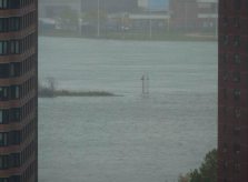
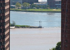
The East River is what’s worrisome: There are whitecaps on the water (another indication of the wind force), and we can see that the water is now overtopping the rocky shoreline of Ward’s Island and flooding into the park above. The tail of Mill Rock is submerged. Here are comparable photos of Mill Rock last year (as it happens, just after Hurricane Irene and Tropical Storm Lee came through :-)) and just now, at high tide:

Now, with submerged “tail”…

Last year

Definitely high water, and we haven’t even gotten started yet…

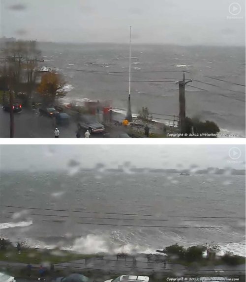
Fortunately, we’re sitting up here warm and dry, have power (so far), and the wonder of webcams allows us to see what is happening farther afield. Here’s what it looks like on Staten Island:

Part 3 —>

Sandy Saga, Part 1

By Johna Till Johnson and Vladimir Brezina

Wind forecast for 7pm Monday 10/29/12, from NOAA’s North American Mesoscale (NAM) model, showing winds blowing into NY Harbor at 45-50mph (red color) and even 50-55mph (magenta). The eye of the storm is the region with weak winds (white). Reproduced from SeaAndSkyNY.

Here’s your “feet-on-the-street” reporting from Hurricane/Nor’easter/Frankenstorm Sandy, from NYC. Please keep in mind that, as of this posting, we have no idea whatever what is going to happen—all we know is what the models forecast. Future posts will describe what actually did happen.

For an ongoing update, please check Philip Orton’s blog, SeaAndSkyNY. He’s an oceanographer and scientist whose data and insights we rely on regularly.

(For an amusing assessment of models and the people who create them, we recommend this xkcd cartoon. Be sure to mouse over the cartoon and read the comment that pops up.)

Friday 10/26/12, noon-ish. We decide to cancel our planned weekend camping trip up the Hudson, on the grounds that if Amtrak shuts down, we’ll be stranded. Little do we know we are going to miss out on the excitement of finding a body near our planned campground

Saturday 10/27/12, morning. “We should get some supplies,” Vlad says. Since this is more or less what Johna has been thinking since we’d cancelled the camping trip, we are pretty much in alignment. (Vlad’s comment takes a generalized anxiety and makes it immediately actionable.)

So we run out and lay in supplies: salami, cheese, nuts, crunchy veggies, anything tasty and filling that doesn’t require cooking (in case of a power outage.) Plus food that can be cooked, in case the power is functional but the rest of NY infrastructure is not: sausages, meat.

Saturday 10/27/12, afternoon. Gowanus Canal paddle. We’re out for four-and-a-half hours in New York Harbor, mostly poking around.  (Photos are here.) The salient elements—from the standpoint of an incoming hurricane—have to do with changes in the weather. When we set out it is overcast and warm—warm enough that Johna is overheating in her brand-new wetsuit and wetshirt. By the end of the afternoon, the wind has picked up and changed direction—instead of coming from the south/southwest, it is coming from the east. And we are happy to be wearing the wetsuits.

The most exotic part, though, is the sundog. If you’ve never seen one before (Johna hadn’t), they’re awesome. Looks like a brilliant double-rainbow in the sky—until you notice the two rainbows are symmetrical and curved facing each other, on either side of the sun. The sundog guides our travel most of the way home.

Sunday, 1o/28/12, noon-ish. New York City announces the shutdown of subways and buses. Amtrak closes lines, thus validating our decision not to go camping.

We rejigger plans (both professional and personal) to handle contingencies. The sky is slate-gray, but no wind or rain.

Sunday 10/28/12, afternoon.  We are out and about. The wind has picked up, it’s definitely colder, and there’s a tang in the air that smells like snow to come—slightly odd since the temperature feels like the high 50s.

Sunday 10/28/12, 4:40 PM. The wind picks up even more, sending dry leaves dancing. A feathery smattering of rain sprays down, but nothing lasting. If you didn’t know better, you’d think this was an ordinary late-October day: cool, overcast, breezy, drizzly.

Sunday 10/28/12, 5:00 PM. The first serious gust kicks in. It’s still no more than 20-30 mph (hard to gauge on land) but something about it feels serious. Then it dies down.

Sunday 10/28/12, 5:30 PM. The local Duane Reade is sold out of bottled water. Also canned goods. But not, fortunately, of staples like olives and ice (for martinis).

Sunday 10/28/12, 9:15 PM. Stepping out of the neighborhood restaurant where we’ve had dinner, we’re greeted with a sustained blast of wind. Still no rain, though. Halloween decorations rattle (we wonder how well they’ll survive the next few days).

More to come…

Part 2 —>

The 2011 Hurricane Season in 4.5 Minutes

By Vladimir Brezina

Today, November 30, is the last day of this year’s hurricane season.

Hurricanes don’t know that it’s the last day of the season, of course, and in some years they’ve continued well past this date. The hurricane season of 2005, for example, lasted into January 2006; there were so many tropical cyclones that year—among them Katrina and Wilma, respectively the costliest and the most intense Atlantic hurricanes on record—that the prepared names were all used up and six Greek-letter names had to be used.

This year, we are only up to Tropical Storm Sean, so far. This time-lapse satellite-image video compresses the entire 2011 hurricane season into 4.5 minutes. Nothing really striking happens until half-way through the season when the impressive bulk of Hurricane Irene moves up the East Coast of the US… But the time-lapse format does give a powerful impression of the swirling of the weather systems and the recurved paths of the storms—the Coriolis force in action!

A Walk in the Park

By Vladimir Brezina

Yesterday:

Today:

More photos from both days to come. (Update, November 18, 2011: they are here.)