By Vladimir Brezina

High on our list of paddling priorities for this summer has been the Staten Island circumnavigation.
It’s a trip that has everything—the busy New York Harbor and the open water of the Lower Bay, islands and lighthouses, surf on sandy beaches, grassy creeks and salt marshes, wildlife, heavy industry, decayed piers, shipwrecks, huge container ports, container ships, barges, and tugs of all shapes and sizes, imposing bridges, and finally the Statue of Liberty and the Manhattan skyline glowing in the sunset or, after it, sparkling with a myriad lights…
And all this in just twelve hours of paddling!
We used to do a Staten Island circumnavigation often, but suddenly we realized we hadn’t done one for two years—since Hurricane Sandy, in fact. We wondered how Sandy might have changed the familiar landmarks…
And the long days of summer were drawing to an end.
So on Saturday we went. Here are some photos.

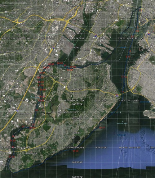
Our GPS track, with the locations of the photos indicated. Click to expand.
(click on any photo to start slideshow)

We leave Pier 40

… and paddle down the Hudson

It’s a cloudy day—it’s not going to be too hot!

We cross from the Battery to Governors Island

It’s going to be a fun trip!

Manhattan Island

The sun appears for a moment to light up the Statue

Across Bay Ridge Flats

We leave the city behind

Through the anchorage

… and out toward the Narrows

Red on gray

Last glimpse of Manhattan

Under the Verrazano-Narrows Bridge

Out into the Lower Bay

Coney Island sinks below the horizon

Open water

Sailboats parade out from Great Kills

That one seems to be scudding along nicely

Hey! I can do that too. I put up my sail

Round the southwest corner of Staten Island into the Arthur Kill

Under the Outerbridge Bridge….

Misty in light rain showers

Every buoy has its gull

Industrial scene

Ardmore Seavantage

Our favorite ruined McMyler Coal Unloader (see
here)

Ahead, the garbage mountain of Fresh Kills

Other marine skeletons, too

Sadly, there is fresh blood in the Graveyard—
John B. Caddell, a victim of Sandy

Graveyard of Ships 1

Graveyard of Ships 2

Graveyard of Ships 3

Graveyard of Ships 4

Graveyard of Ships 5

Graveyard of Ships 6

Graveyard of Ships 7

Graveyard of Ships 8

Graveyard of Ships 9

Graveyard of Ships 10

Graveyard of Ships 11. Signs of life…

Graveyard of Ships 12. “Marooned, high tide, but among giants; river city heroes. I should have moved to Brooklyn.”

Graveyard of Ships 13

Graveyard of Ships 14

Graveyard of Ships 15

Graveyard of Ships 16

Graveyard of Ships 17

Graveyard of Ships 18

Graveyard of Ships 19

Onward past Fresh Kills, now attractively verdant

Power plant against eggshell blue sky

Encounter of species

Tugboat convention

We follow the channel

… but then take the cut behind Pralls Island

Industry…

… gives way to nature

Hopeful

Planes landing at Newark every minute are now our constant companions

We paddle back out into the main channel of Arthur Kill

Another power station on the Jersey side

Steaming

Meanwhile, on the Staten Island side… antlers!

There are two of them

Industrial landscape 1

Dark into light

The sky well matches the scene

Powerful

It’s an amazing sight

Green arm

Tug traffic increases

Australian Spirit

Industrial landscape 2

Phoenix Marine

Two bridges ahead

Industrial landscape 3

Goethals Bridge and an old railroad bridge

Liquid light

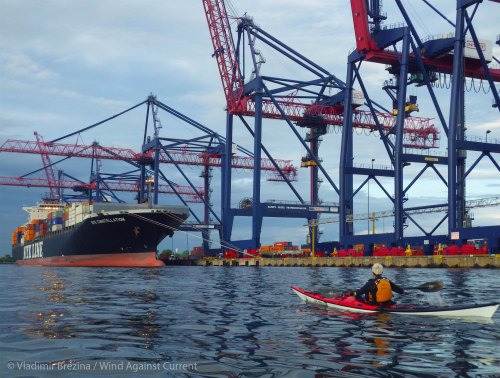
Is there a container ship in port? Yes, there is!

Under the railroad bridge

Howland Hook Container Terminal

We paddle up

NYK Constellation—we saw her come through the Narrows in the morning

The setting sun pierces the clouds just at the right moment

Lit up against the dark sky

We look up in awe

A distant Manhattan ahead

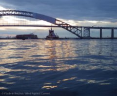
… and the Bayonne Bridge

The wind has died down completely

Unfortunately, another container ship is leaving Port Elizabeth

Last rays of the sun

We paddle to the Bayonne Bridge

All sorts of barges

You Go Girl

The Bayonne Bridge illuminated

Under the bridge

Tug-to-tug rescue

The container ship is making the turn and will follow us through the Kill van Kull…
Then it got too dark to take pictures. But the most exciting part of the trip was still to come! The paddle through the narrow Kill van Kull in a dense traffic of tugs, barges, and that container ship following just behind us… The crossing of the mouth of the Kill van Kull in the dark, from one flashing buoy to the next… The paddle through dark smooth waters past the Statue of Liberty, the sparkling skyline of Manhattan growing ever larger… And finally the crossing of the Hudson back to Pier 40, weaving through the procession of loud party boats on their Saturday-night promenade…
Altogether, 42 nautical miles (about 48 land miles).


I’ve said it before but I have to say it again – you bring such a unique perspective to travel in NYC. Such a treat to read/view your blog.
LikeLike
Thanks for reading, and thanks for continuing to say it!
LikeLike
Good Grief I was paddling along Great Kills myself that same day , too bad I didn’t come across you two , I would have gave you an escort through My stomping grounds :) . 42 mi ,12 hrs ! Please tell Me you got out at some point to stretch ?
LikeLike
Too bad we missed each other!
We did get out for half an hour or so at Tottenville—not to stretch, but to eat some lunch. When it’s warm, and there is a convenient beach handy, we do that. If not, not—we just raft up and eat on the water. In winter that’s much more pleasant…
LikeLike
Very cool. I want to join next time! I am still out in British Columbia, kayaking and also dragon-boating. “See you in September.!
LikeLike
Sounds like a wonderful summer! We need to get together when you get back…
LikeLike
I like your posts a lot and the photos make it possible to be there:))
LikeLike
Glad to have you along! :-)
LikeLike
Cool set, the wreck is great!
LikeLike
Yes, the wrecks are the star attraction on this trip :-)
LikeLike
I was sitting on your shoulder, loved the tour and the up close photos of the graveyard . The water looks like glass in one shot! Also the change in daylight and the buck! So fun and thanks for letting us live vicariously with you both!
LikeLike
You are most welcome!!
You do see it all in one day during this trip :-)
LikeLike
Wonderful urban paddle with a few touches forever wild. My favorite area the graveyard of ships, stunning photos from the kayaker’s perspective, best view on the water.
LikeLike
The Graveyard is always a favorite. Unfortunately there is less and less of it each year. On the other hand again, they’ve added the first new wreck, the John B. Caddell, in what must be decades. It gleams strangely white among all that old rusty metal…
LikeLike
Wow. I’d love to see all this for myself. Sounds like kayaking is the only way. It’s tempting, but since I’d be a beginner, probably not in my near future. I’m glad I got to see it through your eyes.
LikeLike
Well, it is possible to visit some of the sections by kayak without too much trouble. In particular, the Graveyard of Ships—people launch a couple of miles away for a short paddle to the Graveyard. And yes, a kayak (or other small boat) is by far the best way to see the Graveyard…
LikeLike
Looks like a wonderful day – amazing clouds, & the graveyard is fascinating.
LikeLike
Clouds always add so much. A clear blue sunny sky is boring, as well as hot, during the summer. During the winter it’s a little more welcome ;-)
LikeLike
Yes, you definitely picked the right day for it.
LikeLike
On this trip, there are almost always clouds. That’s because you want an easterly wind, to give you a bit of a push down the long southern shore of Staten Island. And an easterly wind usually means a weather system of some kind, with clouds and rain. We had light rain showers on and off on Saturday :-)
LikeLike
Sounds perfect.
LikeLike
Great tour and beautiful shots !
It’s always very intersting to see the Big Apple from your point of you !
Ciao ciao
Max
LikeLike
Thanks so much, Max!!
LikeLike
Wow – a journey that has it all and so beautifully recorded!
LikeLike
Thank you, and thanks for following our blog!! :-)
LikeLike
Our pleasure – we look forward to following you where ever you go!
LikeLike
I haven’t been to the ship graveyard since 2009 but some people that have been there more recently might find these older pics interesting for comparisons sake.
http://www.schiffner.com/image-gallery/?a=vg&g=cschiffner_0.87433400_1252814949&r=1&gp=3
LikeLike
Thanks, Chris! Those are really nice. You took the trouble to go deeper in between the wrecks than we usually do—on a Staten Island circumnavigation such as last weekend’s we usually feel like we have to press on after just half an hour at most at the Graveyard…
But I have been there a number of times over the past fifteen years. My earliest pictures, such as the ones in this post, are from before 2000. And, as your pictures also show, there has indeed been quite a deterioration, especially in recent years. Here’s that iconic ferry at the outer edge of the Graveyard, before 2000:
then in 2010:
in 2012:
and now in 2014:
And it’s great you went inside the Major General William H. Hart!
LikeLike
another fun outing and amazing photos! thanks for the ride! what a treat! :)
LikeLike
Glad to have you along!! :-)
LikeLike
Excellent!!
LikeLike
Thank you!!
LikeLike
Oh thank you guys for taking me back!! I used to inhabit all these spaces, but from the land side. I explored every corner of the island and admired the amazing variety of it, but finally, living there was too stressful. When NYS DOH cut dozens of positions, including mine, it was the writing on the wall, and I moved out here to the Seattle area. So it’s good to revel in the nostalgia for a very unique location, and your photos are just excellent. (I saw that deterioration in the shipwrecks over just 4 years of living there. Not to mention the shoreline after a huge storm…)
LikeLike
Yes, Staten Island has, and gets, it all… This is the state of it now. We’ll continue to bring further reports in future years! :-)
LikeLike
Pingback: Broken | Wind Against Current
Its been a year but hope to revive this post… I’d like to row around staten island in the next few weeks or so and could use some advice. Did you use Eldridge to time your route with currents, at least as much as that’s possible? I’d be starting at Great Kills harbor on the south shore, so only 36 miles or so for me.
Thanks!
LikeLike
Hi, Peter,
Sorry for the late reply—we were away in Australia.
Yes, definitely do time your trip to take advantage of the currents. They are significant everywhere around Staten Island except along the south shore. We no longer use Eldridge to look up the currents, but the little chartlets that Eldridge reprints each year are useful to understand the general nature of the current flows. For more information on tides and currents in New York Harbor see this post.
Do contact us if you need more specific information!
LikeLike
Hi Vladimir –
Many thanks for the reply. I’ve used Eldridge for years sailing and in my rowing around Raritan Bay. But the information along the Kill van Kull and channel was difficult to read… Anyway, I’ve since done some more snooping about your site and found the link to the Stevens Tech current charts, very nice… And with their help I’ve changed my plan to a clock-wise tour, alert in the morning up the channel, then letting some nice currents bring me home in the afternoon down thru the narrows and even a bit along the south shore. And I can always hope there isn’t a stiff westerly on my nose… a lot more windage on my Chester Yawl skiff than your kayak… -:) Anyway, no boat traffic to speak of along South Beach, all the better after a long row and my back no doubt screaming.
I’ll post some questions to your Australia site – i have a morbid fascination with salt water crocs.
cheers,
Peter
LikeLike
That sounds like a good plan. The key point to remember is that (as the Stevens site shows quite well) the currents in the Kills round the back of Staten Island split, or combine, at Shooters Island at the bottom of Newark Bay. That is, for much of the time that the current flows down Newark Bay, it then splits at Shooters Island to flow southwest down the Arthur Kill, and east down the Kill van Kull. Or, in reverse, it flows northeast up the Arthur Kill and west up the Kill van Kull to combine at Shooters Island and then flow up Newark Bay. The current through the Kill van Kull can be quite strong, that through the Arthur Kill not nearly as strong.
Our plan when we circumnavigate Staten Island from Manhattan, also clockwise, is therefore to ride the current up the Arthur Kill so as to arrive at Shooters Island at the tail end of that current, and then pick up the current already flowing down the Kill van Kull.
It’s very desirable to have current with you, rather than against you, through the Kill van Kull, as that is probably the busiest waterway in New York Harbor. In particular, it is the home of many of the harbor’s tugs, which pop in and out of the embayments along the Kill van Kull without any warning. So it’s good to get through there as fast as possible.
With regard to the wind, yes, we don’t like westerly wind for the circumnavigation: it can make the south shore, where there isn’t much helpful current, a real slog. We look for easterly wind—that is, some kind of weather system :-)
LikeLike